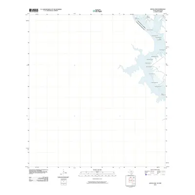
2010 Map of Zapata NW
USGS Topo · Published 2010About this map
Old Raotireno Cemetery stands as a focal point for genealogical interest along the eastern shores of Falcon Reservoir. This portion of the borderlands, where the United States and Mexico meet, is defined by the submerged path of the Rio Grande. The map details the complex shoreline of the reservoir, specifically highlighting the navigational channel through a series of numbered markers, including Buoy Number 33 and Buoy Number 18. The landscape is characterized by the expansive water of the reservoir and the international boundary that follows the original riverbed, providing a specific look at the Zapata County shoreline during the early twenty-first century.
Find a feature on this map
18 named features on this map. Tap any name to fly to it.
Don’t see what you’re looking for? This feature index may not catch every label — zoom into the map to look around manually.
Map Details
Editions of this 2010 Zapata NW Map
This is the sole edition of this map. No revisions or reprints were ever made.
Other maps of this area

1942 · San Ygnacio
USGS Topo · 1:62,500

1949 · Mc Allen
USGS Topo · 1:250,000

1954 · McAllen
USGS Topo · 1:250,000

1956 · Zapata
USGS Topo · 1:62,500

1956 · Laredo
USGS Topo · 1:250,000

1957 · Mc Allen
USGS Topo · 1:250,000

1962 · McAllen
USGS Topo · 1:250,000
1979 · Zapata
USGS Topo · 1:24,000
1979 · Zapata SE
USGS Topo · 1:24,000
1979 · Zapata NW
USGS Topo · 1:24,000