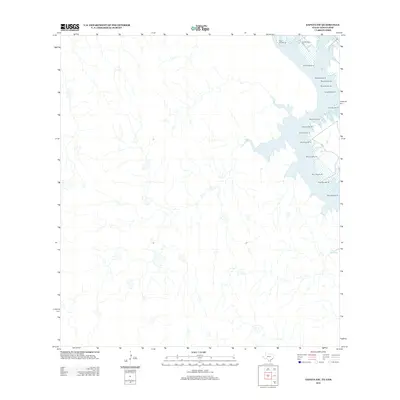
2012 Map of Zapata NW
USGS Topo · Published 2012About this map
Falcon Reservoir dominates the eastern edge of this South Texas landscape, defined by the intricate shoreline of the Rio Grande's impounded waters. Along these banks, the Old Raotireno Cem remains a significant cultural landmark for those tracing local family lineages in Zapata County. The map details a strictly regulated waterway, marked by a precise series of navigational aids ranging from Buoy Number 33 in the north to Buoy Number 18 further south. Away from the water, the terrain is characterized by a network of seasonal drainages and arroyos that feed into the reservoir, illustrating the hydrological patterns of the brush country in the early twenty-first century.
Find a feature on this map
17 named features on this map. Tap any name to fly to it.
Don’t see what you’re looking for? This feature index may not catch every label — zoom into the map to look around manually.
Map Details
Editions of this 2012 Zapata NW Map
This is the sole edition of this map. No revisions or reprints were ever made.
Other maps of this area

1942 · San Ygnacio
USGS Topo · 1:62,500

1949 · Mc Allen
USGS Topo · 1:250,000

1954 · McAllen
USGS Topo · 1:250,000

1956 · Zapata
USGS Topo · 1:62,500

1956 · Laredo
USGS Topo · 1:250,000

1957 · Mc Allen
USGS Topo · 1:250,000

1962 · McAllen
USGS Topo · 1:250,000
1979 · Zapata
USGS Topo · 1:24,000
1979 · Zapata SE
USGS Topo · 1:24,000
1979 · Zapata NW
USGS Topo · 1:24,000