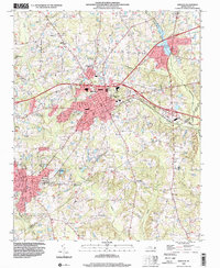
1999 Map of Zebulon
USGS Topo · Published 2000About this map
Zebulon and its surrounding communities in eastern Wake County are captured here at the close of the 20th century. The landscape is defined by the winding course of the Little River and the convergence of several major county boundaries, including Franklin, Nash, and Johnston. Educational history is well represented with the locations of Wakelon High Sch, Shepard High Sch, and Carver Sch, while the religious fabric of the area is mapped through numerous country churches like Union Chapel and St Pauls Ch.
Find a feature on this map
36 named features on this map. Tap any name to fly to it.
Don’t see what you’re looking for? This feature index may not catch every label — zoom into the map to look around manually.
Map Details
Editions of this 1999 Zebulon Map
This is the sole edition of this map. No revisions or reprints were ever made.
Other maps of this area

1902 · Kenly
USGS Topo · 1:62,500

1902 · Spring Hope
USGS Topo · 1:62,500

1903 · Kenly
USGS Topo · 1:62,500

1904 · Springhope
USGS Topo · 1:62,500

1953 · Raleigh
USGS Topo · 1:250,000

1954 · Raleigh
USGS Topo · 1:250,000

1964 · Flowers
USGS Topo · 1:24,000

1964 · Selma
USGS Topo · 1:62,500

1964 · Clayton
USGS Topo · 1:24,000

1967 · Knightdale
USGS Topo · 1:24,000