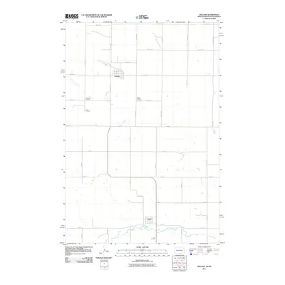
2011 Map of Zeeland
USGS Topo · Published 2011About this map
Zeeland anchors the northern portion of this prairie landscape, where the grid of McIntosh County meets the South Dakota border. This 2011 survey captures the agricultural heart of the region, defined by the winding course of Spring Creek as it flows near the southern settlement of Artas. The area is characterized by its rural isolation and a strong sense of community heritage, evidenced by the multiple denominational and local burial grounds scattered across the townships. Genealogists and local historians can locate the Reformed Cemetery, Zion Cemetery, and Saint Andrew Cemetery in the vicinity of Zeeland, while the Artas Cemetery serves the southern end of the quadrangle. The connection between these two towns is maintained via Artas Rd, reflecting a transportation network designed around the needs of a sparse, farming population in the early 21st century.
Find a feature on this map
18 named features on this map. Tap any name to fly to it.
Don’t see what you’re looking for? This feature index may not catch every label — zoom into the map to look around manually.
Map Details
Editions of this 2011 Zeeland Map
This is the sole edition of this map. No revisions or reprints were ever made.
Other maps of this area

1953 · Jamestown
USGS Topo · 1:250,000

1954 · Aberdeen
USGS Topo · 1:250,000

1956 · Aberdeen
USGS Topo · 1:250,000

1956 · Jamestown
USGS Topo · 1:250,000

1978 · Greenway
USGS Topo · 1:24,000

1978 · Zeeland
USGS Topo · 1:24,000
1978 · Zeeland NW
USGS Topo · 1:24,000

1978 · Eureka West
USGS Topo · 1:24,000

1978 · Mutske Lake
USGS Topo · 1:24,000
1978 · Zeeland SW
USGS Topo · 1:24,000