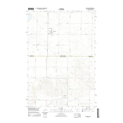
2014 Map of Zeeland
USGS Topo · Published 2014About this map
Zeeland and Artas anchor this prairie landscape along the border of North Dakota and South Dakota. In the northern portion of the map, Zeeland's grid is defined by streets such as Maple St and Railway St, reflecting the transportation roots common to the region's agricultural settlements. Traveling south across the Mcintosh Co Campbell Co line, the terrain gradually descends toward Spring Creek, which meanders near the southern boundary. This area is notably dense with small cemeteries that serve the local rural community, including the Reformed Cem, Zion Cem, and Saint Andrew Cem. The connectivity between these two small towns is maintained by SD-271, providing a clear look at the spatial relationship between these cross-border neighbors in the early 21st century.
Find a feature on this map
26 named features on this map. Tap any name to fly to it.
Don’t see what you’re looking for? This feature index may not catch every label — zoom into the map to look around manually.
Map Details
Editions of this 2014 Zeeland Map
This is the sole edition of this map. No revisions or reprints were ever made.
Other maps of this area

1953 · Jamestown
USGS Topo · 1:250,000

1954 · Aberdeen
USGS Topo · 1:250,000

1956 · Aberdeen
USGS Topo · 1:250,000

1956 · Jamestown
USGS Topo · 1:250,000

1978 · Greenway
USGS Topo · 1:24,000

1978 · Zeeland
USGS Topo · 1:24,000
1978 · Zeeland NW
USGS Topo · 1:24,000

1978 · Eureka West
USGS Topo · 1:24,000

1978 · Mutske Lake
USGS Topo · 1:24,000
1978 · Zeeland SW
USGS Topo · 1:24,000