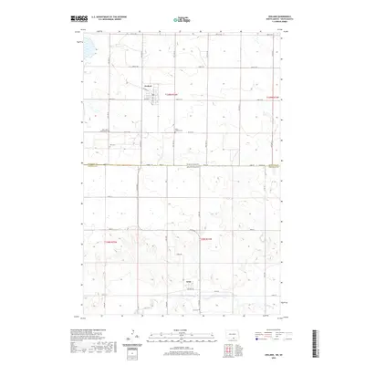
2020 Map of Zeeland
USGS Topo · Published 2020About this map
The town of Zeeland sits at the northern edge of this boundary landscape, where the prairie of North Dakota meets the South Dakota state line. This survey captures a rural agricultural region defined by a precise section-line road grid, including 98th St SE and 100th St SE, which connect isolated farmsteads and historic community hubs. To the south across the McIntosh Co Campbell Co line lies Artas, another small settlement situated near the winding course of Spring Creek. For local historians and genealogists, the map is especially valuable for identifying several denominational burial grounds that punctuate the landscape, including Saint Johns Reformed Cem, Saint Andrews Cem, and Zion Cem. These sites, along with Artas Cem near the southern border, reflect the heritage of the early families who settled this cross-border region.
Find a feature on this map
39 named features on this map. Tap any name to fly to it.
Don’t see what you’re looking for? This feature index may not catch every label — zoom into the map to look around manually.
Map Details
Editions of this 2020 Zeeland Map
This is the sole edition of this map. No revisions or reprints were ever made.
Other maps of this area

1953 · Jamestown
USGS Topo · 1:250,000

1954 · Aberdeen
USGS Topo · 1:250,000

1956 · Aberdeen
USGS Topo · 1:250,000

1956 · Jamestown
USGS Topo · 1:250,000

1978 · Greenway
USGS Topo · 1:24,000

1978 · Zeeland
USGS Topo · 1:24,000
1978 · Zeeland NW
USGS Topo · 1:24,000

1978 · Eureka West
USGS Topo · 1:24,000

1978 · Mutske Lake
USGS Topo · 1:24,000
1978 · Zeeland SW
USGS Topo · 1:24,000