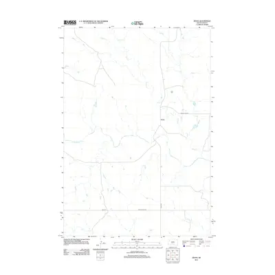
2012 Map of Zeona
USGS Topo · Published 2012About this map
The community of Zeona sits at a remote crossroads in Perkins County, serving as a focal point for the surrounding prairie landscape. This 2012 survey shows the settlement's reliance on a network of unpaved arteries, including Zeona Rd and Hoover Zeona Rd, which connect the scattered ranchlands of western South Dakota. The topography is defined by the winding course of the N Fork Moreau River, which meanders across the southern portion of the quadrangle, joined by tributaries such as Sheep Cr and Ash Cr. For those researching local families, the presence of the Ruby Cem north of the main settlement offers a specific site for genealogical study. The map illustrates a vast, open territory where water sources and road junctions dictate the pattern of human presence and ranching infrastructure.
Find a feature on this map
8 named features on this map. Tap any name to fly to it.
Don’t see what you’re looking for? This feature index may not catch every label — zoom into the map to look around manually.
Map Details
Editions of this 2012 Zeona Map
This is the sole edition of this map. No revisions or reprints were ever made.
Other maps of this area

1935 · Hoover
USGS Topo · 1:125,000

1954 · Lemmon
USGS Topo · 1:250,000

1957 · Lemmon
USGS Topo · 1:250,000

1968 · Sheep Mountain
USGS Topo · 1:24,000
1978 · Fish Draw
USGS Topo · 1:24,000
1978 · Tomato Can Buttes
USGS Topo · 1:24,000

1980 · Redig
USGS Topo · 1:100,000

1980 · Beverly Creek
USGS Topo · 1:25,000

1980 · Zeona
USGS Topo · 1:25,000

1983 · Sorum SE
USGS Topo · 1:24,000