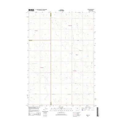
2015 Map of Zeona
USGS Topo · Published 2015About this map
The small community of Zeona sits at the heart of this rangeland landscape, situated near the convergence of several rural thoroughfares. This portion of South Dakota is defined by the winding course of the N Fork Moreau River and its seasonal tributaries, including Sheep Cr and Ash Cr. The map captures a high-prairie environment where the boundaries of Harding, Butte, and Perkins counties meet, illustrating the jurisdictional intersection of this sparsely populated region. For those researching local burial sites or genealogy, Ruby Cem is clearly marked in the northern hills above the river valley. The road network, including Moreau River Rd and Hoover Zeona Rd, reflects the essential pathways connecting isolated homesteads to the central settlement of Zeona during the early 21st century.
Find a feature on this map
18 named features on this map. Tap any name to fly to it.
Don’t see what you’re looking for? This feature index may not catch every label — zoom into the map to look around manually.
Map Details
Editions of this 2015 Zeona Map
This is the sole edition of this map. No revisions or reprints were ever made.
Other maps of this area

1935 · Hoover
USGS Topo · 1:125,000

1954 · Lemmon
USGS Topo · 1:250,000

1957 · Lemmon
USGS Topo · 1:250,000

1968 · Sheep Mountain
USGS Topo · 1:24,000
1978 · Fish Draw
USGS Topo · 1:24,000
1978 · Tomato Can Buttes
USGS Topo · 1:24,000

1980 · Redig
USGS Topo · 1:100,000

1980 · Beverly Creek
USGS Topo · 1:25,000

1980 · Zeona
USGS Topo · 1:25,000

1983 · Sorum SE
USGS Topo · 1:24,000