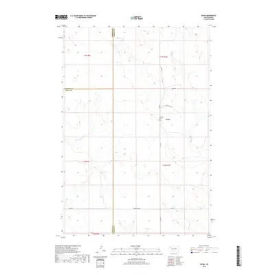
2017 Map of Zeona
USGS Topo · Published 2017About this map
Zeona serves as a small anchor in this rural Perkins County landscape, situated at the junction of local routes where the High Plains terrain is carved by the N Fork Moreau River. The map documents a sparsely settled region defined by its watercourses, including Sheep Cr and Ash Cr, which provide vital drainage for the surrounding ranchlands. Genealogists and local historians will find significant markers of community history at the Immanuel Lutheran Cem and Ruby Cem. The landscape is organized by a network of county roads such as Zeona Rd and Hoover Zeona Rd, which trace the township and range lines. The tri-county corner where Harding Co, Perkins Co, and Butte Co meet highlights the administrative boundaries that have shaped land ownership and governance in this part of South Dakota for generations.
Find a feature on this map
18 named features on this map. Tap any name to fly to it.
Don’t see what you’re looking for? This feature index may not catch every label — zoom into the map to look around manually.
Map Details
Editions of this 2017 Zeona Map
This is the sole edition of this map. No revisions or reprints were ever made.
Other maps of this area

1935 · Hoover
USGS Topo · 1:125,000

1954 · Lemmon
USGS Topo · 1:250,000

1957 · Lemmon
USGS Topo · 1:250,000

1968 · Sheep Mountain
USGS Topo · 1:24,000
1978 · Fish Draw
USGS Topo · 1:24,000
1978 · Tomato Can Buttes
USGS Topo · 1:24,000

1980 · Redig
USGS Topo · 1:100,000

1980 · Beverly Creek
USGS Topo · 1:25,000

1980 · Zeona
USGS Topo · 1:25,000

1983 · Sorum SE
USGS Topo · 1:24,000