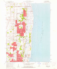
1960 Map of Zion
USGS Topo · Published 1962About this map
The Lake Michigan shoreline at the dawn of the 1960s reveals a dense network of civic and religious institutions along the Wisconsin-Illinois State Line. The city of Zion is clearly defined by its grid, featuring numerous local landmarks such as City Hall, Shiloh Park, and specialized schools including Jack Benny Jr High Sch and Our Lady of Humility Sch. To the north, Winthrop Harbor marks the border, while the southern portion of the sheet transitions into the industrial and urban landscape of Waukegan, dominated by Victory Memorial Hospital and the Waukegan Memorial Airport.
Find a feature on this map
52 named features on this map. Tap any name to fly to it.
Don’t see what you’re looking for? This feature index may not catch every label — zoom into the map to look around manually.
Map Details
Editions of this 1960 Zion Map
3 editions found
Other maps of this area

1892 · Racine
USGS Topo · 1:62,500

1905 · Racine
USGS Topo · 1:62,500

1906 · Waukegan
USGS Topo · 1:62,500

1908 · Waukegan
USGS Topo · 1:62,500
1958 · Kenosha
USGS Topo · 1:24,000
1958 · Pleasant Prairie
USGS Topo · 1:24,000

1958 · Racine
USGS Topo · 1:250,000
1959 · Racine
USGS Topo · 1:62,500
1960 · Waukegan
USGS Topo · 1:24,000
1960 · Waukegan
USGS Topo · 1:62,500