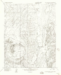
1955 Map of Zith-Tusayan Butte 1 NE
USGS Topo · Published 1958About this map
The high-desert terrain of the Navajo Indian Reservation straddles the border of Arizona and New Mexico in this mid-century survey. The landscape is dominated by the broad elevation of the Defiance Plateau and the volcanic caldera of Buell Park, a distinctive circular depression flanked by Buell Mtn and Peridot Ridge. This geological transition point shows the descent from the plateau into Red Valley and Beautiful Valley, where drainage systems like Black Creek and Tohdildonih Wash carve the basin floor. Human activity is marked by sparse infrastructure, including a Jeep Trail and several Windmills, highlighting the region's reliance on groundwater management. Notable landmarks such as Starrett Mesa and Frog Rock provide clear reference points within this complex topography of mesas and washes.
Find a feature on this map
27 named features on this map. Tap any name to fly to it.
Don’t see what you’re looking for? This feature index may not catch every label — zoom into the map to look around manually.
Map Details
Editions of this 1955 Zith-Tusayan Butte 1 NE Map
This is the sole edition of this map. No revisions or reprints were ever made.
Other maps of this area

1886 · Wingate
USGS Topo · 1:250,000

1886 · Fort Defiance
USGS Topo · 1:250,000

1889 · Chaco
USGS Topo · 1:250,000

1892 · Fort Defiance
USGS Topo · 1:250,000

1892 · Wingate
USGS Topo · 1:250,000

1892 · Chaco
USGS Topo · 1:250,000

1892 · Canyon De Chelly
USGS Topo · 1:250,000

1954 · Shiprock
USGS Topo · 1:250,000

1954 · Gallup
USGS Topo · 1:250,000

1955 · Zith-Tusayan Butte 1 SE
USGS Topo · 1:24,000