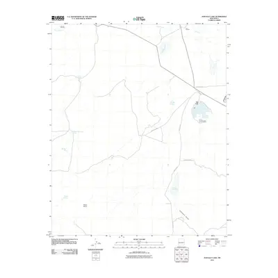
2010 Map of Zuni Salt Lake
USGS Topo · Published 2010About this map
Zuñi Salt Lake dominates the eastern landscape of this high-desert region, serving as a center for both unique geology and local industry. The presence of the Zuñi Salt Lake Mine adjacent to the water indicates the ongoing economic importance of this natural salt source, while scattered infrastructure like Leon Windmill and Mireles Windmill point to the necessary adaptations for ranching and survival in an arid environment. The terrain is marked by seasonal and permanent water catchments, including Chical Lake, Lunas Lake, and Cheap John Lake, which disrupt the dry expanse of Mesita Blanca. Drainage systems such as Carrizo Wash and Largo Creek provide the primary natural corridors through the varied topography of Cottonwood Canyon, while the local road network, including County Rd-A7, links these disparate water sources and industrial sites across Catron County.
Find a feature on this map
22 named features on this map. Tap any name to fly to it.
Don’t see what you’re looking for? This feature index may not catch every label — zoom into the map to look around manually.
Map Details
Editions of this 2010 Zuni Salt Lake Map
This is the sole edition of this map. No revisions or reprints were ever made.
Other maps of this area

1954 · Saint Johns
USGS Topo · 1:250,000

1957 · Saint Johns
USGS Topo · 1:250,000

1958 · Saint Johns
USGS Topo · 1:250,000

1962 · Saint Johns
USGS Topo · 1:250,000

1972 · Zuni Salt Lake
USGS Topo · 1:24,000

1972 · Lake Armijo
USGS Topo · 1:24,000

1972 · Twentytwo Spring
USGS Topo · 1:24,000

1972 · Fence Lake SW
USGS Topo · 1:24,000

1972 · Blaines Lake
USGS Topo · 1:24,000
1972 · Moreno Hill
USGS Topo · 1:24,000