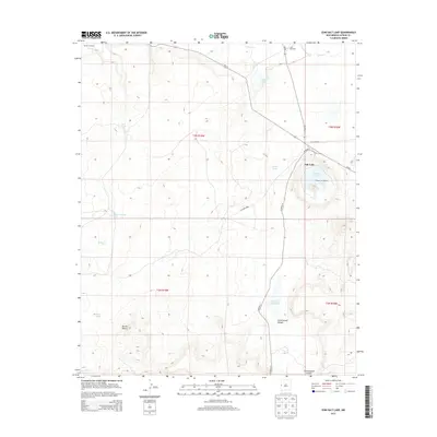
2013 Map of Zuni Salt Lake
USGS Topo · Published 2013About this map
Zuni Salt Lake dominates the eastern edge of this high-desert landscape in Catron County, New Mexico. This distinctive geological feature, surrounded by the high rim of Salt Lake, serves as the focal point for a region defined by its ephemeral hydrology and traditional land use. The map highlights sacred terrain such as Ahayu:t an Yalanne, rising above the volcanic crater. Water management is critical in this arid environment, evidenced by scattered livestock infrastructure like Mireles Windmill and Leon Windmill, alongside numerous seasonal water bodies including Lunas Lake and Cheap John Lake. The network of backroads, including CO Road A7 and CO Road A012, connects these remote reaches where drainage systems like Carrizo Wash and Largo Cr cut through the terrain toward Cottonwood Canyon.
Find a feature on this map
27 named features on this map. Tap any name to fly to it.
Don’t see what you’re looking for? This feature index may not catch every label — zoom into the map to look around manually.
Map Details
Editions of this 2013 Zuni Salt Lake Map
This is the sole edition of this map. No revisions or reprints were ever made.
Other maps of this area

1954 · Saint Johns
USGS Topo · 1:250,000

1957 · Saint Johns
USGS Topo · 1:250,000

1958 · Saint Johns
USGS Topo · 1:250,000

1962 · Saint Johns
USGS Topo · 1:250,000

1972 · Zuni Salt Lake
USGS Topo · 1:24,000

1972 · Lake Armijo
USGS Topo · 1:24,000

1972 · Twentytwo Spring
USGS Topo · 1:24,000

1972 · Fence Lake SW
USGS Topo · 1:24,000

1972 · Blaines Lake
USGS Topo · 1:24,000
1972 · Moreno Hill
USGS Topo · 1:24,000