1990s Maps of Uman, Chuuk
Explore 2 historic maps of Uman from the 1990s. These maps offer a rare glimpse into what life looked like during the 1990s — showing old roads, neighborhoods, homes, and landmarks that have changed or disappeared over time.
Whether you're researching your family's past, planning a metal detecting trip, or studying how Uman's landscape evolved across the 1990s, these high-resolution maps are a powerful tool for exploring the history of this region.
- Focus on a specific era: All maps on this page are from the 1990s, giving you a focused view of this time period.
- See what’s changed: Compare century-old streets, trails, and buildings to today's modern landscape using overlays and satellite layers.
- Research with precision: Use these maps for genealogy, historical research, land use analysis, or educational projects.
- View, download, or print: Maps are fully viewable online in high resolution, and can be downloaded or printed for your own records.
Start exploring Uman's history through authentic maps from the 1990s. This is your window into the past.
Uman, TRK maps
(2)- 1996 Map of Neoch, 2004 Print
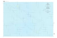 1996 Neoch2004 Print · USGSThe remote atoll of Neoch in the Chuuk State is detailed here in the late twentieth century, showing the isolation of these Micronesian islands. Researchers can trace the perimeter of the coral reef to find small landforms like Feneppi, Ipis, and Fanait.
 - 1997 Map of Weno, 2004 Print
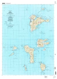 1997 Weno2004 Print · USGSChuuk Lagoon in the late nineties is presented here through the detailed geography of Weno and its surrounding volcanic islands. Genealogists and researchers can locate coastal settlements like Mechitiw and Sapuk, alongside schools such as Chuuk High Sch.
End of results
Showing maps 1-2 of 2
Frequently asked questions
- What are the different types of historical maps available for Uman?
- What is the oldest map of Uman?
- Where can I purchase historical maps of Uman for my home or office?
- Where can I download high-res historical maps of Uman?
- Are there historical topographic maps available for Uman?
- Is there historical aerial imagery available for Uman?
- Where are historical maps of Uman sourced from?