Old Maps of Uman, Chuuk for Hiking & Exploration
Hike through history with 2 historic maps of Uman. Explore old trails, ghost towns, and forgotten backroads — perfect for outdoor adventurers and local explorers.
- Rediscover forgotten places: Map out old mining camps, roads, and footpaths that no longer exist on modern maps.
- Layer with modern tools: Combine with LiDAR or satellite views to plan hikes through historical terrain.
- Made for exploration: Popular among hikers, overlanders, and local history lovers.
Use these maps to find adventure and explore the hidden past of Uman.
Uman, TRK maps
(2)- 1996 Map of Neoch, 2004 Print
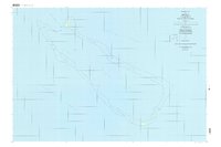 1996 Neoch2004 Print · USGSThe remote atoll of Neoch in the Chuuk State is detailed here in the late twentieth century, showing the isolation of these Micronesian islands. Researchers can trace the perimeter of the coral reef to find small landforms like Feneppi, Ipis, and Fanait.
 - 1997 Map of Weno, 2004 Print
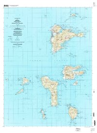 1997 Weno2004 Print · USGSChuuk Lagoon in the late nineties is presented here through the detailed geography of Weno and its surrounding volcanic islands. Genealogists and researchers can locate coastal settlements like Mechitiw and Sapuk, alongside schools such as Chuuk High Sch.
End of results
Showing maps 1-2 of 2
Frequently asked questions
- What are the different types of historical maps available for Uman?
- What is the oldest map of Uman?
- Where can I purchase historical maps of Uman for my home or office?
- Where can I download high-res historical maps of Uman?
- Are there historical topographic maps available for Uman?
- Is there historical aerial imagery available for Uman?
- Where are historical maps of Uman sourced from?