Old Maps of Uman, Chuuk for Academic Research
Study the evolution of Uman with 2 high-resolution historic maps. Whether you're teaching, researching, or modeling changes in land use, these maps provide essential visual documentation of urban, environmental, and geographic change.
- Analyze long-term change: Track patterns in development, transportation, and natural features.
- Ideal for environmental or urban studies: Support academic projects with primary historical map data.
- Use in the classroom or lab: Educators and researchers rely on these maps to bring historical context to life.
These maps are a powerful tool for teaching, research, and visualizing how Uman has changed over the decades.
Uman, TRK maps
(2)- 1996 Map of Neoch, 2004 Print
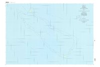 1996 Neoch2004 Print · USGSThe remote atoll of Neoch in the Chuuk State is detailed here in the late twentieth century, showing the isolation of these Micronesian islands. Researchers can trace the perimeter of the coral reef to find small landforms like Feneppi, Ipis, and Fanait.
 - 1997 Map of Weno, 2004 Print
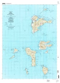 1997 Weno2004 Print · USGSChuuk Lagoon in the late nineties is presented here through the detailed geography of Weno and its surrounding volcanic islands. Genealogists and researchers can locate coastal settlements like Mechitiw and Sapuk, alongside schools such as Chuuk High Sch.
End of results
Showing maps 1-2 of 2
Frequently asked questions
- What are the different types of historical maps available for Uman?
- What is the oldest map of Uman?
- Where can I purchase historical maps of Uman for my home or office?
- Where can I download high-res historical maps of Uman?
- Are there historical topographic maps available for Uman?
- Is there historical aerial imagery available for Uman?
- Where are historical maps of Uman sourced from?