1940s Maps of Gulf Shores, Alabama
Explore 5 historic maps of Gulf Shores from the 1940s. These maps offer a rare glimpse into what life looked like during the 1940s — showing old roads, neighborhoods, homes, and landmarks that have changed or disappeared over time.
Whether you're researching your family's past, planning a metal detecting trip, or studying how Gulf Shores's landscape evolved across the 1940s, these high-resolution maps are a powerful tool for exploring the history of this region.
- Focus on a specific era: All maps on this page are from the 1940s, giving you a focused view of this time period.
- See what’s changed: Compare century-old streets, trails, and buildings to today's modern landscape using overlays and satellite layers.
- Research with precision: Use these maps for genealogy, historical research, land use analysis, or educational projects.
- View, download, or print: Maps are fully viewable online in high resolution, and can be downloaded or printed for your own records.
Start exploring Gulf Shores's history through authentic maps from the 1940s. This is your window into the past.
Gulf Shores, AL maps
(5)- 1941 Map of Foley, 1964 Print
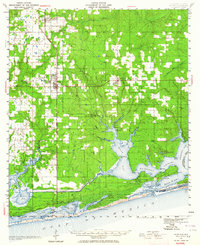 1941 Foley1964 Print · USGSCoastal Baldwin County in the early 1940s shows the working landscape of the Gulf before the era of major development. Researchers can trace the Louisville and Nashville Railroad line, find local landmarks like Stone Quarry Bayou, and locate early community sites such as Miflin Sch.3 unique versions available
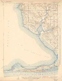
 - 1941 Map of Weeks Bay, 1965 Print
 1941 Weeks Bay1965 Print · USGSThe Alabama coast at the start of the 1940s reveals a world of bayous, river landings, and quiet maritime settlements. Trace family roots and local history through landmarks like Magnolia Springs, the Confederate Rest Cem, and Springhill Sch.2 unique versions available
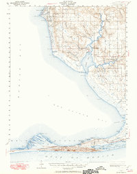
 - 1943 Map of Weeks Bay
 1943 Weeks Bay1943 Print · USGSBaldwin County's shoreline and river systems are captured here in the early 1940s, just as the coastal landscape was modernizing. Genealogists can trace family names and local sites at Confederate Rest Cem, Magnolia Springs, and McKenzie Ferry.3 unique versions available
 - 1943 Map of Foley
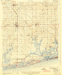 1943 Foley1943 Print · USGSCoastal Baldwin County in the early 1940s shows a landscape of rail-end farming hubs and quiet bayou settlements before the rise of modern tourism. Genealogists and historians can trace local family roots through sites like Summerdale Cem, the Little Rock School, and the fishing village of Bon Secour.2 unique versions available
 - 1944 Map of Miflin
 1944 Miflin1944 Print · USGSCoastal Alabama and the Florida borderlands are captured here during the mid-forties, showing the quiet maritime life of the Gulf shore. Researchers can trace family-named points and old settlements like Josephine, Perdido Beach, and the Josephine School.
End of results
Showing maps 1-5 of 5
Top cities near Gulf Shores
- Fairhope historical maps
- Foley historical maps
- Orange Beach historical maps
- Point Clear historical maps
- Elberta historical maps
- Bon Secour historical maps
See more
Top neighborhoods of Gulf Shores
Frequently asked questions
- What are the different types of historical maps available for Gulf Shores?
- What is the oldest map of Gulf Shores?
- Where can I purchase historical maps of Gulf Shores for my home or office?
- Where can I download high-res historical maps of Gulf Shores?
- Are there historical topographic maps available for Gulf Shores?
- Is there historical aerial imagery available for Gulf Shores?
- Where are historical maps of Gulf Shores sourced from?