1980s Maps of Gulf Shores, Alabama
Explore 4 historic maps of Gulf Shores from the 1980s. These maps offer a rare glimpse into what life looked like during the 1980s — showing old roads, neighborhoods, homes, and landmarks that have changed or disappeared over time.
Whether you're researching your family's past, planning a metal detecting trip, or studying how Gulf Shores's landscape evolved across the 1980s, these high-resolution maps are a powerful tool for exploring the history of this region.
- Focus on a specific era: All maps on this page are from the 1980s, giving you a focused view of this time period.
- See what’s changed: Compare century-old streets, trails, and buildings to today's modern landscape using overlays and satellite layers.
- Research with precision: Use these maps for genealogy, historical research, land use analysis, or educational projects.
- View, download, or print: Maps are fully viewable online in high resolution, and can be downloaded or printed for your own records.
Start exploring Gulf Shores's history through authentic maps from the 1980s. This is your window into the past.
Gulf Shores, AL maps
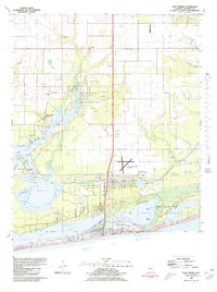
(4)- 1980 Map of Orange Beach
 1980 Orange Beach1980 Print · USGSCoastal Alabama was entering a new era of development in the late seventies, centered on the waterways of Baldwin County. Local historians can trace the early layouts of Orange Beach, the residential expansion on Ono Island, and landmarks like Lay Cem or the U S Naval Res Wolf Field.2 unique versions available
 - 1980 Map of Bon Secour Bay
 1980 Bon Secour Bay1980 Print · USGSCoastal Baldwin County is captured here in the late seventies, showing the vital maritime corridor where the Intracoastal Waterway meets the bay. Genealogists and local historians can locate Gasque, Shellbank Ch, and Miller Memorial Cem along the southern shore.2 unique versions available
 - 1980 Map of Gulf Shores
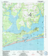
 1980 Gulf Shores1980 Print · USGSGulf Shores and the Baldwin County coast are captured here in 1980, showcasing a landscape of maritime industry and early tourism. Trace the development of the Intracoastal Waterway and locate local landmarks like Swift Sch and Jack Edwards Airport.2 unique versions available
 - 1980 Map of Pine Beach
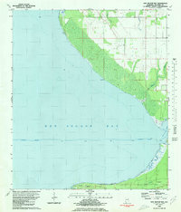
 1980 Pine Beach1980 Print · USGSThe Alabama coast is captured here in the early eighties, showing the thin barrier peninsula between Little Lagoon and the sea. Researchers can trace the early development of Gulf Shores and find local landmarks like Gator Lake and Edith Hammock.
End of results
Showing maps 1-4 of 4
Top cities near Gulf Shores
- Fairhope historical maps
- Foley historical maps
- Orange Beach historical maps
- Point Clear historical maps
- Elberta historical maps
- Bon Secour historical maps
See more
Top neighborhoods of Gulf Shores
Frequently asked questions
- What are the different types of historical maps available for Gulf Shores?
- What is the oldest map of Gulf Shores?
- Where can I purchase historical maps of Gulf Shores for my home or office?
- Where can I download high-res historical maps of Gulf Shores?
- Are there historical topographic maps available for Gulf Shores?
- Is there historical aerial imagery available for Gulf Shores?
- Where are historical maps of Gulf Shores sourced from?