
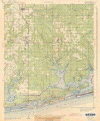
1943 Map of Foley
USGS Topo · Published 1943About this map
Louisville and Nashville tracks terminate in the agricultural hub of Foley, serving as a critical transport link for the coastal settlements of Baldwin County during the early 1940s. The landscape transition from inland farming communities like Summerdale to the intricate bayous and bays of the Gulf Coast is marked by numerous rural landmarks, including the Miflin School and Pleasant View Church. Along the shoreline, the newly established Gulf State Park and the engineering of the Intracoastal Waterway signify the growing importance of the maritime and recreational economy.
Find a feature on this map
70 named features on this map. Tap any name to fly to it.
Don’t see what you’re looking for? This feature index may not catch every label — zoom into the map to look around manually.
Map Details
Editions of this 1943 Foley Map
2 editions found
Other maps of this area

1920 · Robertsdale
USGS Topo · 1:62,500

1921 · Bon Secour
USGS Topo · 1:62,500

1921 · Point Clear
USGS Topo · 1:62,500

1921 · Fairhope
USGS Topo · 1:62,500

1921 · Fort Barrancas
USGS Topo · 1:62,500

1921 · Muscogee
USGS Topo · 1:62,500

1940 · Silverhill
USGS Topo · 1:31,680

1941 · Fort Barrancas
USGS Topo · 1:62,500

1941 · Silverhill
USGS Topo · 1:31,680

1941 · Muscogee
USGS Topo · 1:62,500