1970s Maps of Hayden, Alabama
Explore 6 historic maps of Hayden from the 1970s. These maps offer a rare glimpse into what life looked like during the 1970s — showing old roads, neighborhoods, homes, and landmarks that have changed or disappeared over time.
Whether you're researching your family's past, planning a metal detecting trip, or studying how Hayden's landscape evolved across the 1970s, these high-resolution maps are a powerful tool for exploring the history of this region.
- Focus on a specific era: All maps on this page are from the 1970s, giving you a focused view of this time period.
- See what’s changed: Compare century-old streets, trails, and buildings to today's modern landscape using overlays and satellite layers.
- Research with precision: Use these maps for genealogy, historical research, land use analysis, or educational projects.
- View, download, or print: Maps are fully viewable online in high resolution, and can be downloaded or printed for your own records.
Start exploring Hayden's history through authentic maps from the 1970s. This is your window into the past.
Hayden, AL maps
(6)- 1975 Map of Creel, 1977 Print
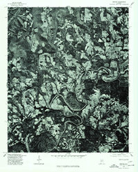
 1975 Creel1977 Print · USGSJefferson County's rural river valleys are captured from above in the mid-seventies, showing the landscape just before modern suburban expansion. Researchers can trace the winding paths of the Mulberry Fork and Locust Fork through undisturbed timber and farmland.
 - 1975 Map of Nectar, 1977 Print
 1975 Nectar1977 Print · USGSBlount County land use and river geography are captured in detail during the mid-seventies. Researchers can trace the sharp meanders of the Locust Fork and locate rural homesteads around Nectar, Locust, and Ville.
 - 1975 Map of Trafford, 1977 Print
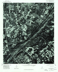
 1975 Trafford1977 Print · USGSNorth-central Alabama comes into clear focus in the mid-seventies through this detailed orthophotograph. Genealogists and land researchers can trace the settlement of Trafford and the winding path of the Locus watercourse.
 - 1975 Map of Warrior, 1977 Print
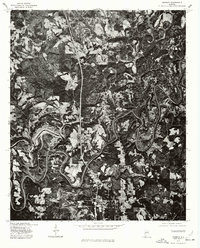 1975 Warrior1977 Print · USGSJefferson County in the mid-seventies is seen here through high-resolution aerial imagery, revealing the literal landscape of the Alabama coal belt. Local historians can trace the exact 1975 footprints of Warrior and Kimberly alongside the winding Fork.
 - 1975 Map of Blount Springs, 1977 Print
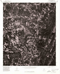
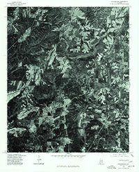
 1975 Blount Springs1977 Print · USGSBlount County land use and river geography are captured in detail during the mid-seventies. Researchers can trace the windings of the Mulberry Fork and locate building footprints in the vicinity of Blount Springs and Hayden.
 - 1975 Map of Arkadelphia, 1977 Print
 1975 Arkadelphia1977 Print · USGSSouthern Cullman County is captured in photographic detail during the mid-seventies, showing the rural landscape just before modern expansion. Genealogists and land researchers can trace property lines and forest clearings around Arkadelphia, Bremen, and the winding Mulberry Fork.
End of results
Showing maps 1-6 of 6
Top cities near Hayden
- Trussville historical maps
- Cullman historical maps
- Gardendale historical maps
- Clay historical maps
- Pinson historical maps
- Oneonta historical maps
See more
Frequently asked questions
- What are the different types of historical maps available for Hayden?
- What is the oldest map of Hayden?
- Where can I purchase historical maps of Hayden for my home or office?
- Where can I download high-res historical maps of Hayden?
- Are there historical topographic maps available for Hayden?
- Is there historical aerial imagery available for Hayden?
- Where are historical maps of Hayden sourced from?