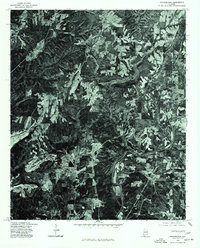
1975 Map of Arkadelphia
USGS Topo · Published 1977About this map
Arkadelphia and Bremen anchor this mid-1970s orthophotoquad, which provides a photographic look at the landscape of southern Cullman County. Unlike traditional topographic maps, this imagery-based survey captures the exact footprint of forest clearings, agricultural fields, and rural residential clusters as they existed in late 1975. The course of the Mulberry Fork winds through the southern portion of the sheet, its wooded banks contrasting with the pale, geometric shapes of cleared land and local industrial or mining sites. This specific photographic record, produced in cooperation with the Soil Conservation Service, offers a distinct view of land use and vegetation patterns during a period of transition in Alabama's hill country.
Find a feature on this map
3 named features on this map. Tap any name to fly to it.
Don’t see what you’re looking for? This feature index may not catch every label — zoom into the map to look around manually.
Map Details
Editions of this 1975 Arkadelphia Map
This is the sole edition of this map. No revisions or reprints were ever made.
Other maps of this area

1888 · Cullman
USGS Topo · 1:125,000

1889 · Birmingham
USGS Topo · 1:125,000

1892 · Cullman
USGS Topo · 1:125,000

1892 · Birmingham
USGS Topo · 1:125,000

1893 · Jasper
USGS Topo · 1:125,000

1895 · Birmingham
USGS Topo · 1:125,000

1907 · Birmingham
USGS Topo · 1:125,000

1949 · Sipsey
USGS Topo · 1:24,000

1949 · Cold Springs
USGS Topo · 1:24,000

1951 · Cold Springs
USGS Topo · 1:24,000