1960s Maps of Bullock County, Alabama
Explore 4 historic maps of Bullock County from the 1960s. These maps offer a rare glimpse into what life looked like during the 1960s — showing old roads, neighborhoods, homes, and landmarks that have changed or disappeared over time.
Whether you're researching your family's past, planning a metal detecting trip, or studying how Bullock County's landscape evolved across the 1960s, these high-resolution maps are a powerful tool for exploring the history of this region.
- Focus on a specific era: All maps on this page are from the 1960s, giving you a focused view of this time period.
- See what’s changed: Compare century-old streets, trails, and buildings to today's modern landscape using overlays and satellite layers.
- Research with precision: Use these maps for genealogy, historical research, land use analysis, or educational projects.
- View, download, or print: Maps are fully viewable online in high resolution, and can be downloaded or printed for your own records.
Start exploring Bullock County's history through authentic maps from the 1960s. This is your window into the past.
Bullock County, AL maps
(4)- 1968 Map of Perote, 1970 Print
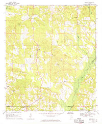 1968 Perote1970 Print · USGSSoutheastern Bullock County and its neighbors come alive in this late 1960s survey of Alabama's Black Belt region. Genealogists and local historians can trace family roots through rural landmarks like Blues Old Stand, Smuteye, and the Mt Hilliard Ch cemetery.
 - 1968 Map of Saco, 1971 Print
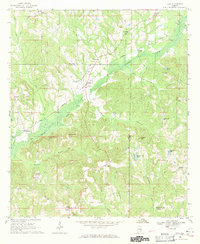 1968 Saco1971 Print · USGSThe rural borderlands of Pike and Bullock Counties come into focus during the late sixties, where the Central of Georgia rail line skirts the Conecuh River. Researchers can trace local genealogy through numerous landmarks including Jones Chapel, Carrs Chapel, and the settlement of Saco.2 unique versions available
 - 1968 Map of Mount Andrew, 1971 Print
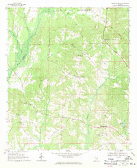 1968 Mount Andrew1971 Print · USGSBarbour County was a landscape of remote crossroads and creek-side mills in the late sixties. Genealogists can trace family footprints through numerous rural landmarks like Street Memorial Ch, Williams Millpond, and the Old Indian Treaty Boundary.
 - 1968 Map of Needmore, 1971 Print
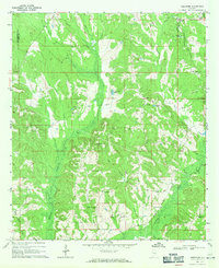 1968 Needmore1971 Print · USGSSoutheast Alabama at the cusp of the 1970s reveals a quiet landscape of rural crossroads and river bottomlands. Researchers can locate family landmarks like Needmore, Tick Hill Cem, and Benevolent Grove Ch along the winding Conecuh River.
End of results
Showing maps 1-4 of 4
Top cities of Bullock County
Frequently asked questions
- What are the different types of historical maps available for Bullock County?
- What is the oldest map of Bullock County?
- Where can I purchase historical maps of Bullock County for my home or office?
- Where can I download high-res historical maps of Bullock County?
- Are there historical topographic maps available for Bullock County?
- Is there historical aerial imagery available for Bullock County?
- Where are historical maps of Bullock County sourced from?