1970s Maps of Bullock County, Alabama
Explore 12 historic maps of Bullock County from the 1970s. These maps offer a rare glimpse into what life looked like during the 1970s — showing old roads, neighborhoods, homes, and landmarks that have changed or disappeared over time.
Whether you're researching your family's past, planning a metal detecting trip, or studying how Bullock County's landscape evolved across the 1970s, these high-resolution maps are a powerful tool for exploring the history of this region.
- Focus on a specific era: All maps on this page are from the 1970s, giving you a focused view of this time period.
- See what’s changed: Compare century-old streets, trails, and buildings to today's modern landscape using overlays and satellite layers.
- Research with precision: Use these maps for genealogy, historical research, land use analysis, or educational projects.
- View, download, or print: Maps are fully viewable online in high resolution, and can be downloaded or printed for your own records.
Start exploring Bullock County's history through authentic maps from the 1970s. This is your window into the past.
Bullock County, AL maps
(12)- 1971 Map of China Grove, 1974 Print
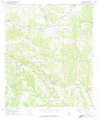
 1971 China Grove1974 Print · USGSThe crossroads of Pike and Bullock counties are captured here in the early seventies, showing a landscape of small rural settlements. Genealogists can trace family footprints through numerous local landmarks like Bethesda Cem, Mt Olive Ch, and Shopton.2 unique versions available
 - 1971 Map of Hardaway, 1974 Print
 1971 Hardaway1974 Print · USGSMacon County in the early seventies remains a landscape of quiet creek-side settlements and rail stops. Researchers can trace the Seaboard Coast Line through Hardaway or locate family roots at Damascus Ch and Mt Pisgah Cem.2 unique versions available
 - 1971 Map of Thompson, 1974 Print
 1971 Thompson1974 Print · USGSIn the early 1970s, this portion of Bullock County was a landscape of rail-fed settlements and historical borders. Genealogists can trace family names at Haines Chapel Cem and Paulk Cem or locate the Central of Georgia rail line near Thompson.2 unique versions available
 - 1971 Map of Fitzpatrick, 1974 Print
 1971 Fitzpatrick1974 Print · USGSBullock County's rural landscape is captured here in the early 1970s, as the railroad network still dictated the pace of local life. Researchers can trace ancestral connections through New Bethel Ch, Panther Cem, and the Old Indian Treaty Bdy near Fitzpatrick.2 unique versions available
 - 1971 Map of Chesson, 1974 Print
 1971 Chesson1974 Print · USGSMacon County's rural landscape is captured here in the early seventies, where rail lines and treaty boundaries still define the local geography. Researchers can trace family roots at Mt Zion Ch, locate the settlement of Chesson, or follow the historic Indian Treaty Boundary.2 unique versions available
 - 1971 Map of Almeria, 1974 Print
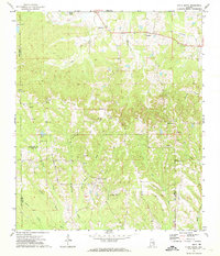
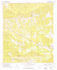
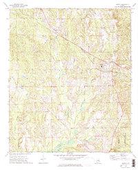
 1971 Almeria1974 Print · USGSBullock County, Alabama, is captured in the early 1970s as a landscape of rural crossroads and family-named landmarks. Researchers can trace the roots of small communities at Hooks Crossroads and Inverness, or locate historic church sites like Mount Hilliard Ch and Faith Tabernacle.
 - 1973 Map of Comer, 1975 Print
 1973 Comer1975 Print · USGSBarbour and Bullock counties in the early seventies remained a landscape of rural tradition and railroad transit. Genealogists and local historians can trace family locations near Great Hope Ch, the Seay Cem, and the tracks of the Central of Georgia near Comer.
 - 1973 Map of Hurtsboro, 1975 Print
 1973 Hurtsboro1975 Print · USGSThe rail crossroads at Hurtsboro remained a vital hub in the 1970s where two major lines intersected. Genealogists can locate several rural landmarks including St Pauls Cem, Enon, and Russell High Sch.
 - 1973 Map of Union Springs, 1976 Print
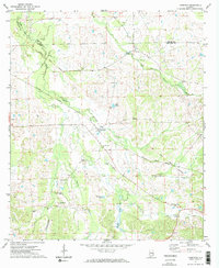
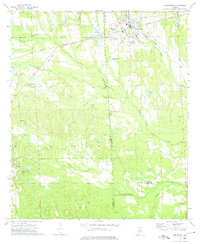
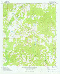
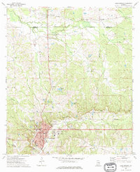 1973 Union Springs1976 Print · USGSUnion Springs and its surrounding Bullock County countryside are captured here in the early 1970s at a peak of rail and agricultural connectivity. Genealogists can trace family roots through numerous sites like Oak Hill Cem, St Paul Ch, and the community of Fort Davis.
 - 1973 Map of Midway, 1976 Print
 1973 Midway1976 Print · USGSMidway and the rural stretches of Bullock and Barbour counties are captured here in the early 1970s. Researchers can trace family history through sites like Johnston Cem and Midway High Sch, or follow the path of the Indian Treaty Boundary.
 - 1973 Map of Roba, 1976 Print
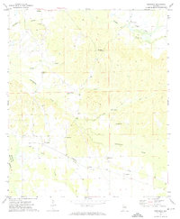
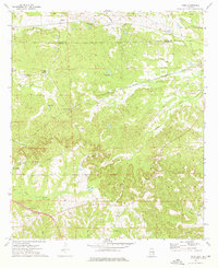 1973 Roba1976 Print · USGSThe borderlands of Bullock and Macon counties are captured here in the early seventies, showing a rural economy built on rail and creek-side industry. Researchers can find many family-history landmarks, from the Jericho Cem to old rail stops at Suspension and Guerryton.2 unique versions available
 - 1973 Map of Aberfoil, 1976 Print
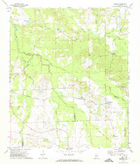
 1973 Aberfoil1976 Print · USGSBullock County settlements south of Union Springs appear in the mid-1970s as the local economy balanced rail transport and clay extraction. Researchers can trace the Indian Treaty Boundary or locate rural family landmarks like Elizabeth Ch and the Dasinger Cem.
End of results
Showing maps 1-12 of 12
Top cities of Bullock County
Frequently asked questions
- What are the different types of historical maps available for Bullock County?
- What is the oldest map of Bullock County?
- Where can I purchase historical maps of Bullock County for my home or office?
- Where can I download high-res historical maps of Bullock County?
- Are there historical topographic maps available for Bullock County?
- Is there historical aerial imagery available for Bullock County?
- Where are historical maps of Bullock County sourced from?