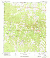
1971 Map of China Grove
USGS Topo · Published 1974About this map
China Grove and the rolling upland terrain of northern Pike and Bullock counties are documented here in the early 1970s. This agricultural landscape is defined by its rural congregations and family cemeteries, including Bethesda Ch, Mt Carmel Ch, and Bethesda Cem. The map reveals a high density of small rural landmarks such as Old Union Ch and Salem Ch, many of which served as the social heart of their respective communities.
Find a feature on this map
34 named features on this map. Tap any name to fly to it.
Don’t see what you’re looking for? This feature index may not catch every label — zoom into the map to look around manually.
Map Details
Editions of this 1971 China Grove Map
2 editions found
Other maps of this area

1953 · Montgomery
USGS Topo · 1:250,000

1953 · Andalusia
USGS Topo · 1:250,000

1953 · Dothan
USGS Topo · 1:250,000

1954 · Dothan
USGS Topo · 1:250,000

1955 · Dothan
USGS Topo · 1:250,000

1955 · Phenix City
USGS Topo · 1:250,000

1956 · Montgomery
USGS Topo · 1:250,000

1957 · Phenix City
USGS Topo · 1:250,000

1957 · Montgomery
USGS Topo · 1:250,000

1957 · Andalusia
USGS Topo · 1:250,000