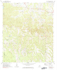
1971 Map of China Grove
USGS Topo · Published 1984About this map
China Grove serves as a central landmark in this 1970s landscape, where the borders of Bullock, Montgomery, and Pike counties converge. The terrain is defined by an intricate network of waterways, including China Grove Creek, Panther Creek, and Log Creek, which carve through the rural countryside. Numerous small rural congregations are documented here, such as Mt Carmel Ch near Pinhook Creek and Friendship Ch to the south. The prevalence of Sandpit sites throughout the central and western portions of the quadrangle suggests localized extractive activity during this era. Long-standing local transit is represented by Grant Ranch Road, while small settlements like Shopton and Hector anchor the northern reaches near the Montgomery County line.
Find a feature on this map
35 named features on this map. Tap any name to fly to it.
Don’t see what you’re looking for? This feature index may not catch every label — zoom into the map to look around manually.
Map Details
Editions of this 1971 China Grove Map
2 editions found
Other maps of this area

1953 · Montgomery
USGS Topo · 1:250,000

1953 · Andalusia
USGS Topo · 1:250,000

1953 · Dothan
USGS Topo · 1:250,000

1954 · Dothan
USGS Topo · 1:250,000

1955 · Dothan
USGS Topo · 1:250,000

1955 · Phenix City
USGS Topo · 1:250,000

1956 · Montgomery
USGS Topo · 1:250,000

1957 · Phenix City
USGS Topo · 1:250,000

1957 · Montgomery
USGS Topo · 1:250,000

1957 · Andalusia
USGS Topo · 1:250,000