1970s Maps of West Bend, Alabama
Explore 1 historic maps of West Bend from the 1970s. These maps offer a rare glimpse into what life looked like during the 1970s — showing old roads, neighborhoods, homes, and landmarks that have changed or disappeared over time.
Whether you're researching your family's past, planning a metal detecting trip, or studying how West Bend's landscape evolved across the 1970s, these high-resolution maps are a powerful tool for exploring the history of this region.
- Focus on a specific era: All maps on this page are from the 1970s, giving you a focused view of this time period.
- See what’s changed: Compare century-old streets, trails, and buildings to today's modern landscape using overlays and satellite layers.
- Research with precision: Use these maps for genealogy, historical research, land use analysis, or educational projects.
- View, download, or print: Maps are fully viewable online in high resolution, and can be downloaded or printed for your own records.
Start exploring West Bend's history through authentic maps from the 1970s. This is your window into the past.
West Bend, AL maps
(1)- 1971 Map of Coffeeville Lock And Dam, 1975 Print
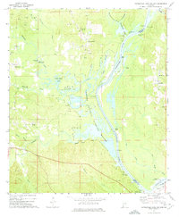 1971 Coffeeville Lock And Dam1975 Print · USGSThe Tombigbee River corridor was undergoing significant change in the 1970s as industrial oil extraction operated alongside new conservation efforts. Researchers can trace river landings like Sellers Landing and find local landmarks such as Pleasant Chapel and Womack Hill.2 unique versions available
End of results
Showing maps 1-1 of 1
Top cities near West Bend
- Gilbertown historical maps
- Millry historical maps
- Silas historical maps
- Coffeeville historical maps
- Toxey historical maps
- Needham historical maps
Frequently asked questions
- What are the different types of historical maps available for West Bend?
- What is the oldest map of West Bend?
- Where can I purchase historical maps of West Bend for my home or office?
- Where can I download high-res historical maps of West Bend?
- Are there historical topographic maps available for West Bend?
- Is there historical aerial imagery available for West Bend?
- Where are historical maps of West Bend sourced from?