1970s Maps of Clay County, Alabama
Explore 11 historic maps of Clay County from the 1970s. These maps offer a rare glimpse into what life looked like during the 1970s — showing old roads, neighborhoods, homes, and landmarks that have changed or disappeared over time.
Whether you're researching your family's past, planning a metal detecting trip, or studying how Clay County's landscape evolved across the 1970s, these high-resolution maps are a powerful tool for exploring the history of this region.
- Focus on a specific era: All maps on this page are from the 1970s, giving you a focused view of this time period.
- See what’s changed: Compare century-old streets, trails, and buildings to today's modern landscape using overlays and satellite layers.
- Research with precision: Use these maps for genealogy, historical research, land use analysis, or educational projects.
- View, download, or print: Maps are fully viewable online in high resolution, and can be downloaded or printed for your own records.
Start exploring Clay County's history through authentic maps from the 1970s. This is your window into the past.
Clay County, AL maps
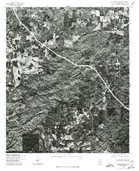
(11)- 1970 Map of Delta, 1973 Print
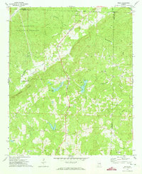 1970 Delta1973 Print · USGSThe upland forests and creek valleys of rural Clay County are captured here in the early 1970s. Genealogists can trace family landmarks like Ragan Chapel Cem and Pleasant Hill Cem near the settlements of Delta and Needmore.2 unique versions available
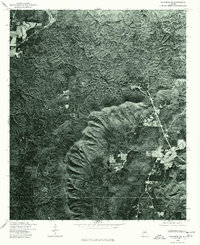
 - 1970 Map of Lineville East, 1973 Print
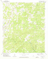 1970 Lineville East1973 Print · USGSClay County's rural heartland is documented here in the early 1970s as agricultural life centered around the railroad and local creeks. Researchers can trace the path of the Seaboard Coast Line or locate family sites like Sweetwater Cem and Barfield.2 unique versions available
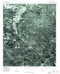
 - 1975 Map of Goodwater SE, 1977 Print
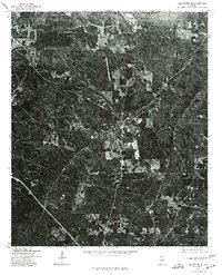 1975 Goodwater SE1977 Print · USGSCoosa County territory during the mid-seventies is revealed through high-resolution aerial imagery centered on the town of Goodwater. Researchers can trace the layout of the settlement and the clearings of nearby homesteads exactly as they appeared just after the war.
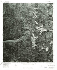
 - 1975 Map of Delta, 1977 Print
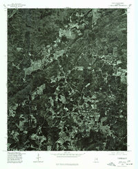 1975 Delta1977 Print · USGSRural Clay County is documented in the mid-seventies through detailed aerial imagery showing the patchwork of forest and field. Genealogists and researchers can trace the roads connecting Delta, Needmore, and the vicinity of Christiana.
 - 1975 Map of Goodwater SW, 1977 Print
 1975 Goodwater SW1977 Print · USGSCoosa County, Alabama is shown here at the height of the 1970s through high-contrast aerial imagery. Local researchers and genealogists can trace the rural road networks and land clearings surrounding Stewartville, Hollins, and Hanover.
 - 1975 Map of Talladega SE, 1977 Print
 1975 Talladega SE1977 Print · USGSTalladega County comes into sharp focus during the mid-seventies in this detailed aerial orthophotograph. Researchers can examine rural land patterns and trace the terrain surrounding Chandlers Springs and the banks of Talladega Creek.
 - 1975 Map of Ironaton, 1977 Print
 1975 Ironaton1977 Print · USGSTalladega County is captured in mid-1970s detail on this aerial-based survey. Local historians can trace the exact physical layout of the landscape around Mc Elderry and Guntertown through actual photo imagery of farms and forests.
 - 1975 Map of Goodwater NW, 1977 Print
 1975 Goodwater NW1977 Print · USGSThe wooded ridges and valley floors of Talladega County are captured in this mid-seventies aerial survey during a period of local expansion. Genealogists and local historians can trace the precise 1975 footprints of Sylacauga and Sycamore against the dense Alabama forest.
 - 1975 Map of Goodwater NE, 1977 Print
 1975 Goodwater NE1977 Print · USGSClay County timberlands and small rural outposts appear in this mid-seventies aerial survey. Genealogists and local researchers can trace the roads and clearings around Shady Grove, Midway, and Brownsville.
 - 1975 Map of Cheaha Mountain, 1977 Print
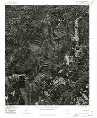 1975 Cheaha Mountain1977 Print · USGSCovers Clay County, including Union, Talladega County, and other nearby areas
 - 1978 Map of La Grange, 1980 Print
 1978 La Grange1980 Print · USGSThe Alabama-Georgia borderlands are captured here in the late seventies, just as the newly formed West Point Lake reshaped the eastern landscape. Local historians can trace the Seaboard Coast Line rail corridor through hubs like Roanoke, Ashland, and Lineville.
End of results
Showing maps 1-11 of 11
Top cities of Clay County
Frequently asked questions
- What are the different types of historical maps available for Clay County?
- What is the oldest map of Clay County?
- Where can I purchase historical maps of Clay County for my home or office?
- Where can I download high-res historical maps of Clay County?
- Are there historical topographic maps available for Clay County?
- Is there historical aerial imagery available for Clay County?
- Where are historical maps of Clay County sourced from?