1980s Maps of Clay County, Alabama
Explore 7 historic maps of Clay County from the 1980s. These maps offer a rare glimpse into what life looked like during the 1980s — showing old roads, neighborhoods, homes, and landmarks that have changed or disappeared over time.
Whether you're researching your family's past, planning a metal detecting trip, or studying how Clay County's landscape evolved across the 1980s, these high-resolution maps are a powerful tool for exploring the history of this region.
- Focus on a specific era: All maps on this page are from the 1980s, giving you a focused view of this time period.
- See what’s changed: Compare century-old streets, trails, and buildings to today's modern landscape using overlays and satellite layers.
- Research with precision: Use these maps for genealogy, historical research, land use analysis, or educational projects.
- View, download, or print: Maps are fully viewable online in high resolution, and can be downloaded or printed for your own records.
Start exploring Clay County's history through authentic maps from the 1980s. This is your window into the past.
Clay County, AL maps
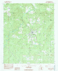
(7)- 1983 Map of Ironaton, 1985 Print
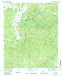 1983 Ironaton1985 Print · USGSTalladega County at the start of the eighties shows a landscape shaped by both forest conservation and industry. Genealogists can locate rural landmarks like Smith Chapel, Ironaton, and the McElderry Grave site along the abandoned rail line.
 - 1984 Map of Hollins
 1984 Hollins1984 Print · USGSCentrally located in Alabama during the mid-eighties, this area shows the intersection of three counties and the Central of Georgia line. Genealogists can locate family landmarks like Shiloh Ch, Mt Pleasant Cem, and Andrew Chapel.
 - 1984 Map of Birmingham South, 1985 Print
 1984 Birmingham South1985 Print · USGSThe Birmingham metropolitan region and the Coosa River valley are shown here in the mid-eighties as suburban growth expanded south into the ridges. Genealogists and local historians can trace the development of communities from Bessemer to Sylacauga alongside the Lay Lake shoreline and the Talladega National Forest.2 unique versions available
 - 1987 Map of Porter Gap
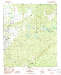
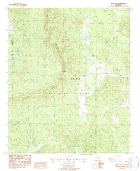
 1987 Porter Gap1987 Print · USGSTalladega and Clay counties are shown here in the late twentieth century as the national forest boundary encompasses prominent ridges and small valleys. Trace family roots at Germany Cem, find old rural congregations like Weewoka Ch, or follow the high Skyway Motorway across Horn Mountain.
 - 1987 Map of Sylacauga East
 1987 Sylacauga East1987 Print · USGSTalladega County's eastern ridges and industrial fringes are captured here in the late eighties, just as the regional rail network was consolidating. Genealogists and historians can trace family-named sites like Evergreen Cem, Indian Valley Sch, and the community of Sycamore.
 - 1987 Map of Goodwater
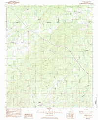
 1987 Goodwater1987 Print · USGSThe town of Goodwater is documented in the late 1980s as a junction of rail and river in the heart of Coosa County. Researchers can trace family sites at Crestview Memorial Cem or locate community landmarks like Goodwater Academy and Marietta Ch.
 - 1987 Map of Bulls Gap
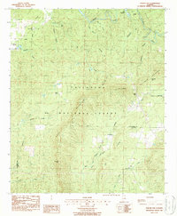
 1987 Bulls Gap1987 Print · USGSThe wooded ridges of Clay and Talladega counties are shown here in the late 1980s as the wilderness of the Talladega National Forest persisted. Researchers can locate remote community hubs like Bull Gap, Hatchet Creek Ch, and Midway tucked between the peaks.
End of results
Showing maps 1-7 of 7
Top cities of Clay County
Frequently asked questions
- What are the different types of historical maps available for Clay County?
- What is the oldest map of Clay County?
- Where can I purchase historical maps of Clay County for my home or office?
- Where can I download high-res historical maps of Clay County?
- Are there historical topographic maps available for Clay County?
- Is there historical aerial imagery available for Clay County?
- Where are historical maps of Clay County sourced from?