1960s Maps of Coffee County, Alabama
Explore 17 historic maps of Coffee County from the 1960s. These maps offer a rare glimpse into what life looked like during the 1960s — showing old roads, neighborhoods, homes, and landmarks that have changed or disappeared over time.
Whether you're researching your family's past, planning a metal detecting trip, or studying how Coffee County's landscape evolved across the 1960s, these high-resolution maps are a powerful tool for exploring the history of this region.
- Focus on a specific era: All maps on this page are from the 1960s, giving you a focused view of this time period.
- See what’s changed: Compare century-old streets, trails, and buildings to today's modern landscape using overlays and satellite layers.
- Research with precision: Use these maps for genealogy, historical research, land use analysis, or educational projects.
- View, download, or print: Maps are fully viewable online in high resolution, and can be downloaded or printed for your own records.
Start exploring Coffee County's history through authentic maps from the 1960s. This is your window into the past.
Coffee County, AL maps
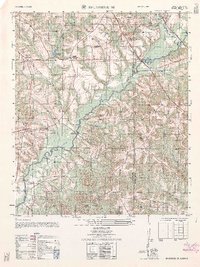
(17)- 1960 Map of Brundidge SE, 1963 Print
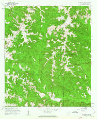
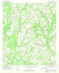
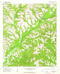 1960 Brundidge SE1963 Print · USGSCoffee County during the early sixties is captured here as a landscape of river-bottom farms and small rail stops. Genealogists can trace the rural communities of Tennille, Roeton, and Java alongside historic landmarks like Prestwood Millpond and New Tabernacle Ch.2 unique versions available
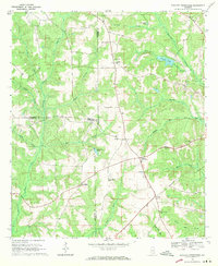
 - 1960 Map of Victoria, 1963 Print
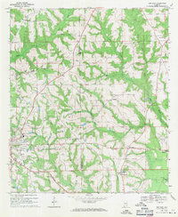
 1960 Victoria1963 Print · USGSDeep in the Alabama wiregrass region during the early sixties, this area shows a landscape defined by the winding Whitewater Creek and the Pea River. Researchers can trace rural life through landmarks like Lowry Mill, Clowers Crossroads, and Bethlehem Ch.2 unique versions available
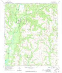
 - 1960 Map of Goodman, 1963 Print
 1960 Goodman1963 Print · USGSCoffee County at the dawn of the sixties shows a patchwork of small farms and rural crossroads before the modern expansion of Enterprise. Genealogists can locate family landmarks like Wooten Chapel, Bethany Ch, and the Meadow Lawn Memorial Park cemetery.2 unique versions available
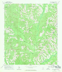
 - 1960 Map of New Brockton, 1963 Print
 1960 New Brockton1963 Print · USGSCoffee County as it appeared in the early sixties was a landscape of river-bank crossings and railroad hamlets. Trace the heritage of the Pea River valley through New Brockton and Clintonville, locating family landmarks like McGee Cem and Shiloh Ch.2 unique versions available
 - 1960 Map of Enterprise NE, 1963 Print
 1960 Enterprise NE1963 Print · USGSIn the Alabama Wiregrass during the early sixties, the landscape was defined by rural church communities and the expansion of the military. Genealogists and historians can trace family sites at Wesley Chapel Cem, Old Tabernacle Ch, and the Fort Rucker U. S. Military Reservation boundary.2 unique versions available
 - 1960 Map of Enterprise, 1964 Print
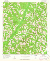
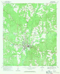
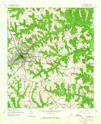 1960 Enterprise1964 Print · USGSEnterprise and the surrounding Wiregrass region are shown here in the early 1960s as military and rail infrastructure shaped the landscape. Researchers can trace rural life through landmarks like Macedonia Cem, Level Plains Crossroads, and the Atlantic Coast Line.3 unique versions available
 - 1962 Map of Victoria
 1962 Victoria1962 Print · USGSThe borderlands of Coffee and Pike County come alive in the early sixties, showing a landscape defined by small farms and country churches. Researchers can locate the Victoria School, the site of Lowry Mill, and local landmarks like Clowers Crossroads.
 - 1962 Map of Enterprise NE
 1962 Enterprise NE1962 Print · USGSSoutheast Alabama is captured in the early sixties as rural farm communities met the expansion of the military. Genealogists and local historians can trace the sites of El Bethel Church, the Ebenezer Cemetery, and old landmarks like the fire tower.
 - 1962 Map of Brundidge SE
 1962 Brundidge SE1962 Print · USGSCoffee and Dale counties in the early sixties reveal a landscape of river-bottom farms and emerging military installations. Genealogists can trace family roots through sites like Tennille, Roeton, and the Mt Olive Cemetery.
 - 1968 Map of Danleys Crossroads, 1970 Print
 1968 Danleys Crossroads1970 Print · USGSSoutheast Alabama in the late sixties reveals a landscape of tight-knit farming communities at the junction of Coffee, Crenshaw, and Covington Counties. Researchers can trace family history through local landmarks like Mt Olive Ch, Danleys Crossroads, and Friendship.2 unique versions available
 - 1968 Map of Ino, 1970 Print
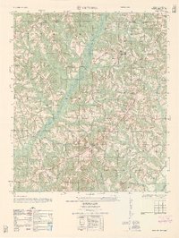
 1968 Ino1970 Print · USGSCoffee County life in the late 1960s centered on the Pea River and its rural settlements. Researchers can trace family roots through sites like Ino, Mt Gilead Ch, and Phillips Cem, or locate infrastructure like the Elba Dam.2 unique versions available
 - 1968 Map of Bluff Springs, 1970 Print
 1968 Bluff Springs1970 Print · USGSSoutheast Alabama in the late sixties reveals a landscape of rural family churches and creek-side settlements along the Pike and Coffee County line. Genealogists and researchers can trace the vicinity of Bluff Springs, the historic Old Sharron Cem, and the crossings at Lewis Mill Bridge.2 unique versions available
 - 1968 Map of Sellersville, 1971 Print
 1968 Sellersville1971 Print · USGSSoutheast Alabama’s agricultural heartland is documented here in the late sixties, showcasing the rural landscape at the border of Coffee and Geneva counties. Genealogists can trace family roots through landmarks like Weeks Cem, Friendship Ch, and the small settlement of Sellersville.2 unique versions available
 - 1968 Map of Opp East, 1971 Print
 1968 Opp East1971 Print · USGSEastern Covington County is documented in the late 1960s as the rail-and-river landscape of the wiregrass region evolved. Trace the Louisville and Nashville line past Skelly Field or locate legacy landmarks like Old Town Cem.2 unique versions available
 - 1968 Map of Elba, 1971 Print
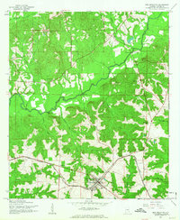
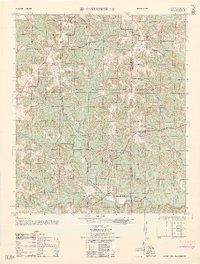
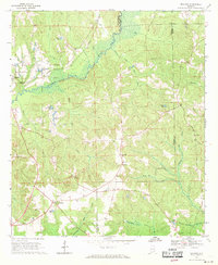
 1968 Elba1971 Print · USGSElba and the surrounding Coffee County countryside are captured here in the late sixties as the city expanded along the Pea River. Genealogists and local historians can locate family landmarks like Evergreen Cemetery, Shiloh Cem, and Wise Mill Ch.2 unique versions available
 - 1968 Map of Bullock, 1971 Print
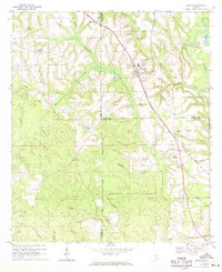
 1968 Bullock1971 Print · USGSCrenshaw County is documented here in the late sixties as the timber and rail economy shaped the rural landscape. Genealogists and local historians can locate many rural landmarks including Mt Zion Ch, Oak Grove Cem, and the Central of Georgia line.
 - 1969 Map of Kinston, 1971 Print
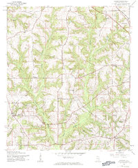
 1969 Kinston1971 Print · USGSSoutheast Alabama is captured here in the late sixties, showcasing the interplay between the Louisville and Nashville rail line and the deep timberlands of the Geneva State Forest. Researchers can locate old crossroads and family sites like Earlytown, St Pauls Cem, and Fine Level Ch.2 unique versions available
End of results
Showing maps 1-17 of 17
Top cities of Coffee County
Frequently asked questions
- What are the different types of historical maps available for Coffee County?
- What is the oldest map of Coffee County?
- Where can I purchase historical maps of Coffee County for my home or office?
- Where can I download high-res historical maps of Coffee County?
- Are there historical topographic maps available for Coffee County?
- Is there historical aerial imagery available for Coffee County?
- Where are historical maps of Coffee County sourced from?