1970s Maps of Florala, Alabama
Explore 3 historic maps of Florala from the 1970s. These maps offer a rare glimpse into what life looked like during the 1970s — showing old roads, neighborhoods, homes, and landmarks that have changed or disappeared over time.
Whether you're researching your family's past, planning a metal detecting trip, or studying how Florala's landscape evolved across the 1970s, these high-resolution maps are a powerful tool for exploring the history of this region.
- Focus on a specific era: All maps on this page are from the 1970s, giving you a focused view of this time period.
- See what’s changed: Compare century-old streets, trails, and buildings to today's modern landscape using overlays and satellite layers.
- Research with precision: Use these maps for genealogy, historical research, land use analysis, or educational projects.
- View, download, or print: Maps are fully viewable online in high resolution, and can be downloaded or printed for your own records.
Start exploring Florala's history through authentic maps from the 1970s. This is your window into the past.
Florala, AL maps
(3)- 1971 Map of Florala, 1973 Print
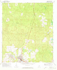 1971 Florala1973 Print · USGSThe Alabama-Florida border comes alive in the early seventies, centered on the lakeside community of Florala and neighboring Lockhart. Genealogists and historians can trace local infrastructure through the Louisville and Nashville Railroad and smaller hubs like Johnsons Quarters.2 unique versions available
 - 1973 Map of Paxton, 1975 Print
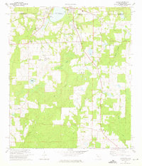 1973 Paxton1975 Print · USGSThe Florida-Alabama borderlands come to life in the early seventies, centered on the rail-side commerce of Paxton and Florala. Local historians can locate specific rural landmarks like St Marks Ch, the Childrens Home, and the Louisville and Nashville rail corridor.3 unique versions available
 - 1978 Map of Crestview, 1982 Print
 1978 Crestview1982 Print · USGSThe Florida Panhandle and southern Alabama borderlands appear here in the late seventies as the military and timber industries shaped the landscape. Genealogists can trace family roots through small settlements like Cannon Town or Svea, and locate old sites like Aux Field No 4 (Abandoned).2 unique versions available
End of results
Showing maps 1-3 of 3
Top cities near Florala
- Crestview historical maps
- Opp historical maps
- Paxton historical maps
- Laurel Hill historical maps
- Kinston historical maps
- Lockhart historical maps
See more
Frequently asked questions
- What are the different types of historical maps available for Florala?
- What is the oldest map of Florala?
- Where can I purchase historical maps of Florala for my home or office?
- Where can I download high-res historical maps of Florala?
- Are there historical topographic maps available for Florala?
- Is there historical aerial imagery available for Florala?
- Where are historical maps of Florala sourced from?