1950s Maps of Cullman County, Alabama
Explore 21 historic maps of Cullman County from the 1950s. These maps offer a rare glimpse into what life looked like during the 1950s — showing old roads, neighborhoods, homes, and landmarks that have changed or disappeared over time.
Whether you're researching your family's past, planning a metal detecting trip, or studying how Cullman County's landscape evolved across the 1950s, these high-resolution maps are a powerful tool for exploring the history of this region.
- Focus on a specific era: All maps on this page are from the 1950s, giving you a focused view of this time period.
- See what’s changed: Compare century-old streets, trails, and buildings to today's modern landscape using overlays and satellite layers.
- Research with precision: Use these maps for genealogy, historical research, land use analysis, or educational projects.
- View, download, or print: Maps are fully viewable online in high resolution, and can be downloaded or printed for your own records.
Start exploring Cullman County's history through authentic maps from the 1950s. This is your window into the past.
Cullman County, AL maps
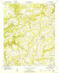
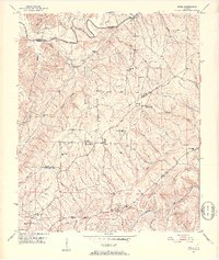
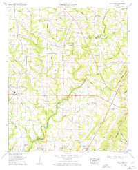
(21)- 1950 Map of Arab
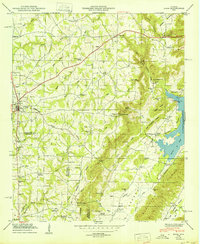 1950 Arab1950 Print · USGSThe Tennessee Valley uplands in the mid-century are captured here, centered on the growing town of Arab and its surrounding ridge-country settlements. Genealogists can trace family landmarks like Johnsons Mill, Ridgway Cem, and the rural community at Brashier Chapel.
 - 1951 Map of Cold Springs
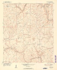
 1951 Cold Springs1951 Print · USGSCullman and Walker Counties are shown here just after mid-century as a landscape of rural ridge-top churches and river-bottom crossings. Genealogists can locate family landmarks like Addington Chapel, McKinley Chapel, and the community of Cold Springs.2 unique versions available
 - 1951 Map of Lawrence Cove
 1951 Lawrence Cove1951 Print · USGSThe Morgan and Cullman county line comes alive in the early fifties, showing a landscape of upland ridges and creek-cut hollows. Genealogists can trace family footprints through numerous country churches like Daniel Chapel and Lystra Ch, or locate the old Lawrence Cove School.2 unique versions available
 - 1951 Map of Sipsey
 1951 Sipsey1951 Print · USGSMid-century Walker County is shown here as a landscape of coal mining and river meanders just as the local industry peaked. Genealogists can trace family names at Rices Chapel, Maudlin Cem, and the rail junction at Sipsey.2 unique versions available
 - 1951 Map of Eva
 1951 Eva1951 Print · USGSThe Morgan and Cullman County line is captured here in the early fifties, showing a rural landscape organized by ridge-top churches and valley coves. Genealogists can locate family landmarks like Childers Cem, Morris Cem, and the Union Hill Church.
 - 1951 Map of Sunlight
 1951 Sunlight1951 Print · USGSWalker County at mid-century shows a landscape of forest and industry just as mining operations began to mark the terrain. Genealogists can trace family roots through numerous country churches like Mt Joy Ch and quiet burial grounds such as Tidwell Cem.2 unique versions available
 - 1951 Map of Falkville
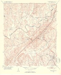
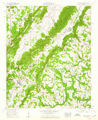
 1951 Falkville1951 Print · USGSThe Morgan and Cullman County line is captured here in the early postwar era, dominated by the rise of Brindley Mountain. Genealogists and local historians can trace family locations near Falkville, the Ebenezer School, and the path of the Old Corn Road.
 - 1951 Map of Arkadelphia, 1952 Print
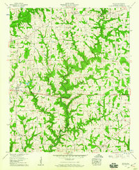
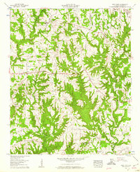
 1951 Arkadelphia1952 Print · USGSCullman County in the early fifties shows a landscape of ridge-top settlements and winding river valleys. Genealogists can locate rural landmarks like The Colony, McDonald Cem, and the Colony School nestled between Arkadelphia Mountain and the Mulberry Fork.5 unique versions available
 - 1951 Map of Creel, 1952 Print
 1951 Creel1952 Print · USGSNorth-Central Alabama in the early fifties was a region of high ridges and winding river forks where rural life centered on small crossroads. Genealogists can locate family landmarks at Partridge Crossroads, Red Hill Sch, and the New Zion Hill Ch community.5 unique versions available
 - 1951 Map of Blount Springs, 1952 Print
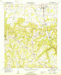
 1951 Blount Springs1952 Print · USGSThe Mulberry Fork and the Louisville and Nashville railroad defined life in these northern Alabama hills during the early fifties. Local historians can trace family locations near Blount Springs, Bangor, and Providence Ch, or locate the Blount Tunnel and Hayden High Sch.5 unique versions available
 - 1952 Map of Hulaco
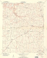 1952 Hulaco1952 Print · USGSAcross the rolling uplands of north Alabama in the early fifties, the Tennessee Valley Divide splits the landscape into distinct drainage basins. Local researchers can trace family roots through numerous rural landmarks like Ryan Crossroads, Hog Jaw, and the Baileyton Cem.2 unique versions available
 - 1953 Map of Birmingham, 1964 Print
 1953 Birmingham1964 Print · USGSCentral Alabama at mid-century shows a landscape defined by industrial expansion and the iron-rich ridges surrounding Birmingham. Researchers can trace the extensive rail networks of the L & N RR or locate historic federal sites like the Anniston Ordnance Depot.4 unique versions available
 - 1956 Map of Birmingham
 1956 Birmingham1956 Print · USGSCentral Alabama in the mid-fifties exhibits a landscape of growing cities and deep-rooted industrial corridors. Genealogists and historians can trace the development of suburban Mountain Brook or locate regional hubs like Sylacauga and Jasper.
 - 1956 Map of Gadsden, 1966 Print
 1956 Gadsden1966 Print · USGSNorth Alabama in the mid-1950s shows a region transformed by river engineering and federal industry. Genealogists and local historians can trace the development of the Tennessee Valley through the growth of Huntsville, the sprawling Redstone Arsenal, and the expansive Guntersville Lake.3 unique versions available
 - 1957 Map of Birmingham
 1957 Birmingham1957 Print · USGSNorth-Central Alabama in the mid-fifties is an industrial powerhouse centered on the steel valleys and sprawling iron ridges. Genealogists and historians can trace the rail-linked growth of Birmingham and Tuscaloosa, or locate rural landmarks like Talladega College and the Anniston Ordnance Depot.
 - 1957 Map of Cullman, 1960 Print
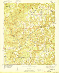
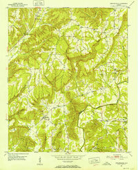
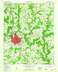 1957 Cullman1960 Print · USGSCullman and the surrounding plateaus of Brindley Mountain are shown here in the late fifties as the city expanded along its historic rail and highway corridors. Genealogists and local historians can locate St Bernard College, the Ave Maria Grotto, and numerous family-named landmarks like Pfal Cem and Kelly Sch.5 unique versions available
 - 1958 Map of Gadsden
 1958 Gadsden1958 Print · USGSNorth Alabama comes alive in the late 1950s as the Tennessee Valley Authority’s massive river projects and the rise of the space industry reshaped the landscape. Researchers can trace the mid-century footprints of Huntsville, Redstone Arsenal, and the riverside rail networks of the Southern railroad.
 - 1958 Map of Simcoe, 1960 Print
 1958 Simcoe1960 Print · USGSCullman County’s rural communities are captured here in the late fifties as small crossroads and family farms defined the landscape. Genealogists can locate family landmarks like Welti Cem or trace the early foundations of Simcoe and Berlin.3 unique versions available
 - 1958 Map of Brooksville, 1960 Print
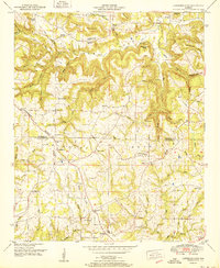
 1958 Brooksville1960 Print · USGSNorth-central Alabama in the late fifties shows a rural landscape defined by deep valleys and the OLD CHEROKEE BOUNDARY. Genealogists and local historians can trace family locations through Eagle Sch, Dickson Cem, and settlements like Brooksville and Summit.3 unique versions available
 - 1958 Map of Holly Pond, 1960 Print
 1958 Holly Pond1960 Print · USGSCullman and Blount Counties come together in the late fifties along the winding Black Warrior River Mulberry Fork. Genealogists can trace family roots through numerous landmarks including Eidson Chapel, New Lebanon Cem, and the Old Cherokee Boundary.3 unique versions available
 - 1958 Map of West Point, 1960 Print
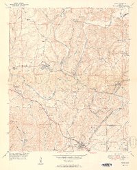
 1958 West Point1960 Print · USGSWest Point and the surrounding Cullman County uplands are captured here in the late fifties, showing a landscape of small farms and ridge-top roads. Researchers can trace family roots through numerous sites like Bethel Ch, Mt Nebo Cem, and the Grandview Lookout Tower.3 unique versions available
End of results
Showing maps 1-21 of 21
Top cities of Cullman County
- Cullman historical maps
- Hanceville historical maps
- Good Hope historical maps
- Holly Pond historical maps
- Baileyton historical maps
- West Point historical maps
See more
Frequently asked questions
- What are the different types of historical maps available for Cullman County?
- What is the oldest map of Cullman County?
- Where can I purchase historical maps of Cullman County for my home or office?
- Where can I download high-res historical maps of Cullman County?
- Are there historical topographic maps available for Cullman County?
- Is there historical aerial imagery available for Cullman County?
- Where are historical maps of Cullman County sourced from?