1970s Maps of Dallas County, Alabama
Explore 15 historic maps of Dallas County from the 1970s. These maps offer a rare glimpse into what life looked like during the 1970s — showing old roads, neighborhoods, homes, and landmarks that have changed or disappeared over time.
Whether you're researching your family's past, planning a metal detecting trip, or studying how Dallas County's landscape evolved across the 1970s, these high-resolution maps are a powerful tool for exploring the history of this region.
- Focus on a specific era: All maps on this page are from the 1970s, giving you a focused view of this time period.
- See what’s changed: Compare century-old streets, trails, and buildings to today's modern landscape using overlays and satellite layers.
- Research with precision: Use these maps for genealogy, historical research, land use analysis, or educational projects.
- View, download, or print: Maps are fully viewable online in high resolution, and can be downloaded or printed for your own records.
Start exploring Dallas County's history through authentic maps from the 1970s. This is your window into the past.
Dallas County, AL maps
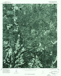
(15)- 1974 Map of Crumptonia, 1977 Print
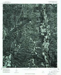
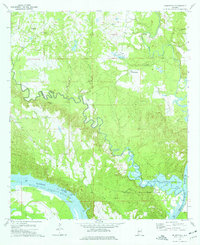 1974 Crumptonia1977 Print · USGSThe Alabama River lowlands in the mid-1970s show a landscape shaped by the William "Bill" Dannelly Reservoir and rural creek valleys. Genealogists can locate family landmarks such as Hardy Young Cem, Aimwell Ch, and the settlement of Crumptonia.
 - 1974 Map of Catherine, 1977 Print
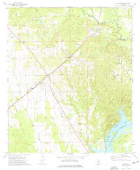 1974 Catherine1977 Print · USGSWilcox and Dallas County communities thrive along the Southern rail corridor in the mid-1970s. Genealogists can trace family names through numerous sites like Catherine Academy, Prairie Bluff Cem, and the old settlement of Rehoboth.
 - 1974 Map of Camden North, 1977 Print
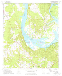 1974 Camden North1977 Print · USGSWilcox County life in the mid-seventies is centered on the wide waters of the Alabama River and the tight-knit communities of Gees Bend. Genealogists and historians can locate numerous rural burial sites and landmarks like Old St Francis Cem, Boykin, and the Lower Coastal Plains Experimental Farm.
 - 1975 Map of Benton SE
 1975 Benton SE1975 Print · USGSBenton and the surrounding Lowndes County bottomlands are captured in detail during the mid-1970s. This aerial orthophotoquad allows researchers to see the actual fields and structures around the Benton settlement and the wide curves of the Alabama River.
 - 1975 Map of Selma NW, 1977 Print
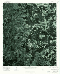 1975 Selma NW1977 Print · USGSDallas County agriculture and rail infrastructure are captured in high detail in the mid-1970s. Genealogists and local historians can trace the physical layout of Marion Junction and the surrounding farmsteads during this era.
 - 1975 Map of Selma SE, 1977 Print
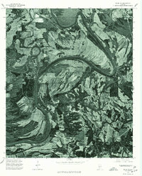 1975 Selma SE1977 Print · USGSThe floodplain south of Selma is captured here in the mid-1970s, showcasing the winding path of the Alabama River. Local researchers can trace old river access points and rural farmsteads near the historic river stop at Kings Landing.
 - 1975 Map of Benton NE, 1977 Print
 1975 Benton NE1977 Print · USGSAutauga County's agricultural heartland and the winding Alabama River are captured in this mid-seventies aerial survey. Researchers can trace the rural landscape around Mulberry and study the intricate river meanders and historic property boundaries.
 - 1975 Map of Carlowville NE, 1977 Print
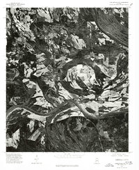
 1975 Carlowville NE1977 Print · USGSThe Alabama riverfront in Dallas County appears in sharp photographic detail in the mid-1970s. Trace the dramatic oxbows of the Alabama River and examine the interplay of timber tracts and agricultural clearings along its fertile banks.
 - 1975 Map of Plantersville SW, 1977 Print
 1975 Plantersville SW1977 Print · USGSCovers Dallas County, including Valley Grande, Jones, and other nearby areas
 - 1975 Map of Benton SW, 1977 Print
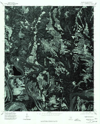
 1975 Benton SW1977 Print · USGSMid-1970s Dallas County comes into sharp focus in this aerial survey of the riverlands east of Selma. Researchers can trace the agricultural footprint and rural infrastructure near Tyler and Sardis, or examine the banks of the Alabama River.
 - 1975 Map of Benton NW, 1977 Print
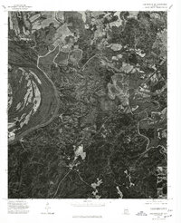
 1975 Benton NW1977 Print · USGSDallas County during the mid-1970s is seen through a detailed aerial lens, capturing the rural landscape between the city and surrounding settlements. Researchers can trace the development of Selma and locate the smaller hubs of Burnsville and Brantley.
 - 1975 Map of Selma SW, 1977 Print
 1975 Selma SW1977 Print · USGSThe rural stretches of Dallas County appear in striking detail during the mid-1970s as agricultural fields meet the deep woods of the Black Belt. Trace land use patterns and field boundaries along the great bend of the Alabama River on this aerial orthophoto.
 - 1975 Map of Summerfield SE, 1977 Print
 1975 Summerfield SE1977 Print · USGSDallas County is captured in mid-1970s aerial detail, documenting the rural landscape and timber tracts of the Alabama interior. Trace local land use and transit patterns along the corridor of State Route 219 as it appeared during the 1975 survey.
 - 1975 Map of Selma, 1977 Print
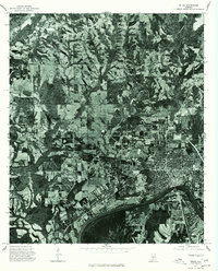 1975 Selma1977 Print · USGSSelma and the surrounding Dallas County countryside are captured in this mid-seventies aerial survey. Researchers can trace the riverfront development along the Alabama River and locate properties near Selma and the rural settlement of Potter.
 - 1975 Map of Carlowville NW, 1977 Print
 1975 Carlowville NW1977 Print · USGSDallas County farm and timber lands are captured from the air in the mid-seventies, showing the rural landscape along the Alabama River. Local historians can trace old property lines and the river-front settlement of Pinebelt in this detailed aerial study.
End of results
Showing maps 1-15 of 15
Top cities of Dallas County
Frequently asked questions
- What are the different types of historical maps available for Dallas County?
- What is the oldest map of Dallas County?
- Where can I purchase historical maps of Dallas County for my home or office?
- Where can I download high-res historical maps of Dallas County?
- Are there historical topographic maps available for Dallas County?
- Is there historical aerial imagery available for Dallas County?
- Where are historical maps of Dallas County sourced from?