1900s (20th Century) Maps of Orrville, Alabama
Explore 8 historic maps of Orrville from the 1900s (20th Century). These maps offer a rare glimpse into what life looked like during the 1900s — showing old roads, neighborhoods, homes, and landmarks that have changed or disappeared over time.
Whether you're researching your family's past, planning a metal detecting trip, or studying how Orrville's landscape evolved across the 1900s, these high-resolution maps are a powerful tool for exploring the history of this region.
- Focus on a specific era: All maps on this page are from the 1900s, giving you a focused view of this time period.
- See what’s changed: Compare century-old streets, trails, and buildings to today's modern landscape using overlays and satellite layers.
- Research with precision: Use these maps for genealogy, historical research, land use analysis, or educational projects.
- View, download, or print: Maps are fully viewable online in high resolution, and can be downloaded or printed for your own records.
Start exploring Orrville's history through authentic maps from the 1900s. This is your window into the past.
Orrville, AL maps
(8)- 1953 Map of Montgomery, 1964 Print
 1953 Montgomery1964 Print · USGSCentral Alabama's river-and-rail corridor is mapped here in the mid-fifties, showing the vital connections between the capital and the Black Belt. Genealogists and historians can trace rail depots and crossroads from Marion Junction to Wetumpka, alongside landmarks like Craig AFB.4 unique versions available
 - 1956 Map of Montgomery
 1956 Montgomery1956 Print · USGSCentral Alabama in the mid-1950s shows a landscape defined by its great river systems and a booming military aviation presence. Genealogists and historians can trace the rail corridors of the Southern Railway and locate tactical bases like Maxwell AFB and Craig AFB.
 - 1957 Map of Montgomery
 1957 Montgomery1957 Print · USGSCentral Alabama in the mid-fifties is defined by the winding Alabama River and a strategic network of military bases and rail lines. Trace family roots in Montgomery and Selma, or locate landmarks like Craig AFB and the State Capitol before the interstate era.
 - 1958 Map of Selma, 1959 Print
 1958 Selma1959 Print · USGSDallas County in the late 1950s centers on the bustling river city of Selma and the critical aviation operations at Craig Air Force Base. Genealogists can trace local roots through numerous rural landmarks like Selma University, Marion Junction, and Childers Chapel Cemetery.3 unique versions available
 - 1968 Map of Safford, 1971 Print
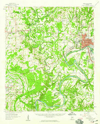
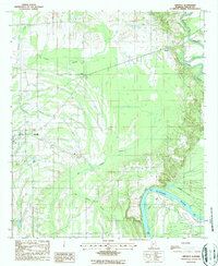
 1968 Safford1971 Print · USGSDallas County in the late sixties is captured here as a network of rail-side settlements and country parishes. Genealogists can locate family-named landmarks like Martin Station Sch, Salem Ch, and the numerous flowing wells near Orrville.2 unique versions available
 - 1975 Map of Selma SW, 1977 Print
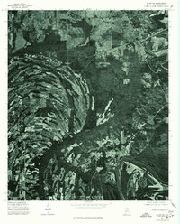 1975 Selma SW1977 Print · USGSThe rural stretches of Dallas County appear in striking detail during the mid-1970s as agricultural fields meet the deep woods of the Black Belt. Trace land use patterns and field boundaries along the great bend of the Alabama River on this aerial orthophoto.
 - 1986 Map of Selma
 1986 Selma1986 Print · USGSCentral Alabama's river and rail networks are preserved here in the mid-eighties, showing the transition from river travel to modern infrastructure. Researchers can trace the layout of Selma, the historic capital at Cahaba, and the Millers Ferry Lock and Dam.2 unique versions available
 - 1987 Map of Orrville
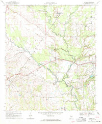
 1987 Orrville1987 Print · USGSIn the late 1980s, the river country of Dallas County remained a landscape of winding waterways and rural crossroads. Genealogists and local historians can trace family-named sites near Orrville, Beloit, and the high ground of Whites Bluff overlooking the Alabama River.
End of results
Showing maps 1-8 of 8
Top cities near Orrville
Frequently asked questions
- What are the different types of historical maps available for Orrville?
- What is the oldest map of Orrville?
- Where can I purchase historical maps of Orrville for my home or office?
- Where can I download high-res historical maps of Orrville?
- Are there historical topographic maps available for Orrville?
- Is there historical aerial imagery available for Orrville?
- Where are historical maps of Orrville sourced from?