1970s Maps of DeKalb County, Alabama
Explore 3 historic maps of DeKalb County from the 1970s. These maps offer a rare glimpse into what life looked like during the 1970s — showing old roads, neighborhoods, homes, and landmarks that have changed or disappeared over time.
Whether you're researching your family's past, planning a metal detecting trip, or studying how DeKalb County's landscape evolved across the 1970s, these high-resolution maps are a powerful tool for exploring the history of this region.
- Focus on a specific era: All maps on this page are from the 1970s, giving you a focused view of this time period.
- See what’s changed: Compare century-old streets, trails, and buildings to today's modern landscape using overlays and satellite layers.
- Research with precision: Use these maps for genealogy, historical research, land use analysis, or educational projects.
- View, download, or print: Maps are fully viewable online in high resolution, and can be downloaded or printed for your own records.
Start exploring DeKalb County's history through authentic maps from the 1970s. This is your window into the past.
DeKalb County, AL maps
(3)- 1975 Map of Dugout Valley, 1977 Print
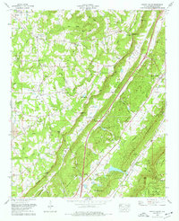 1975 Dugout Valley1977 Print · USGSDeKalb County is captured in the mid-1970s as industrial strip mining and valley farming coexist beneath the heights of LOOKOUT MOUNTAIN. Researchers can trace family sites at Hawkins Chapel, Welcome View Ch, and Price Cem, or follow the old SOUTHERN RAILWAY line through DUGOUT VALLEY.
 - 1975 Map of Crossville, 1977 Print
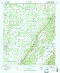 1975 Crossville1977 Print · USGSDeKalb County communities sit atop the Sand Mountain plateau and descend into Big Wills Valley during the mid-seventies. Genealogists can trace family names through the Red Hill Cem and Nicholson Cem or locate rural landmarks like Skirum and Liberty Hill Ch.2 unique versions available
 - 1975 Map of Portersville, 1977 Print
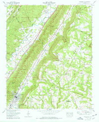 1975 Portersville1977 Print · USGSDeKalb County and the parallel ridges of the Alabama valley-and-ridge country are captured here in the mid-seventies. Genealogists and local historians can trace family burial sites like Warren-Stewart Cem and Plunket Cem or explore the early infrastructure of Collinsville.2 unique versions available
End of results
Showing maps 1-3 of 3
Top cities of DeKalb County
- Fort Payne historical maps
- Rainsville historical maps
- Henagar historical maps
- Collinsville historical maps
- Crossville historical maps
- Sylvania historical maps
See more
Frequently asked questions
- What are the different types of historical maps available for DeKalb County?
- What is the oldest map of DeKalb County?
- Where can I purchase historical maps of DeKalb County for my home or office?
- Where can I download high-res historical maps of DeKalb County?
- Are there historical topographic maps available for DeKalb County?
- Is there historical aerial imagery available for DeKalb County?
- Where are historical maps of DeKalb County sourced from?