1980s Maps of DeKalb County, Alabama
Explore 6 historic maps of DeKalb County from the 1980s. These maps offer a rare glimpse into what life looked like during the 1980s — showing old roads, neighborhoods, homes, and landmarks that have changed or disappeared over time.
Whether you're researching your family's past, planning a metal detecting trip, or studying how DeKalb County's landscape evolved across the 1980s, these high-resolution maps are a powerful tool for exploring the history of this region.
- Focus on a specific era: All maps on this page are from the 1980s, giving you a focused view of this time period.
- See what’s changed: Compare century-old streets, trails, and buildings to today's modern landscape using overlays and satellite layers.
- Research with precision: Use these maps for genealogy, historical research, land use analysis, or educational projects.
- View, download, or print: Maps are fully viewable online in high resolution, and can be downloaded or printed for your own records.
Start exploring DeKalb County's history through authentic maps from the 1980s. This is your window into the past.
DeKalb County, AL maps
(6)- 1981 Map of Chickamauga, 1982 Print
 1981 Chickamauga1982 Print · USGSThe tri-state border region of Georgia, Alabama, and Tennessee comes into focus during the early eighties, defined by the towering ridges of the Appalachians. Historians can trace the preserved grounds of Chickamauga and Chattanooga National Military Park and old rail stops like Rising Fawn or Sulphur Springs.2 unique versions available
 - 1981 Map of Rome, 1982 Print
 1981 Rome1982 Print · USGSNorthwest Georgia and the Alabama borderlands come into focus in the early eighties, defined by the winding Coosa River and the high ridges of Lookout Mountain. Researchers can trace the rail-and-river economy through Rome, Gadsden, and Cedartown, alongside natural landmarks like Yellow Creek Falls.2 unique versions available
 - 1982 Map of Sulphur Springs, 1983 Print
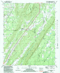 1982 Sulphur Springs1983 Print · USGSThe Alabama and Georgia borderlands in the early eighties were defined by the steep ridges of Lookout Mountain and the Great Southern Railroad. Genealogists can trace family roots at Bible Cem or Pannell Cem and locate old community hubs like Gann Crossroad and Sulphur Springs.
 - 1982 Map of Trenton, 1984 Print
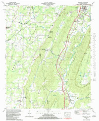 1982 Trenton1984 Print · USGSThe Georgia-Alabama borderlands come into focus in the early eighties as the Alabama Great Southern railroad tracks wind through Lookout Valley. Genealogists and researchers can trace family landmarks like Floral Crest Cem, Newman Cem, and the communities of Rising Fawn and Higdon.
 - 1983 Map of Valley Head
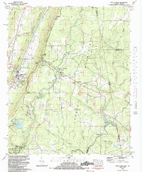 1983 Valley Head1983 Print · USGSThe high plateau of Lookout Mountain meets the valley floor in the 1980s, revealing a landscape shaped by the Little River and the Southern Railroad. Genealogists can trace family landmarks like Holly Spring Cem, Johns Chapel, and the community of Valley Head.
 - 1984 Map of Guntersville, 1985 Print
 1984 Guntersville1985 Print · USGSNorthern Alabama at the start of the eighties shows a landscape shaped by massive TVA impoundments and a robust rail network. Genealogists and historians can trace family land across Brindley Mountain or near old rail stops on the Louisville and Nashville RR and Southern Ry.2 unique versions available
End of results
Showing maps 1-6 of 6
Top cities of DeKalb County
- Fort Payne historical maps
- Rainsville historical maps
- Henagar historical maps
- Collinsville historical maps
- Crossville historical maps
- Sylvania historical maps
See more
Frequently asked questions
- What are the different types of historical maps available for DeKalb County?
- What is the oldest map of DeKalb County?
- Where can I purchase historical maps of DeKalb County for my home or office?
- Where can I download high-res historical maps of DeKalb County?
- Are there historical topographic maps available for DeKalb County?
- Is there historical aerial imagery available for DeKalb County?
- Where are historical maps of DeKalb County sourced from?