1940s Maps of Fayette County, Alabama
Explore 2 historic maps of Fayette County from the 1940s. These maps offer a rare glimpse into what life looked like during the 1940s — showing old roads, neighborhoods, homes, and landmarks that have changed or disappeared over time.
Whether you're researching your family's past, planning a metal detecting trip, or studying how Fayette County's landscape evolved across the 1940s, these high-resolution maps are a powerful tool for exploring the history of this region.
- Focus on a specific era: All maps on this page are from the 1940s, giving you a focused view of this time period.
- See what’s changed: Compare century-old streets, trails, and buildings to today's modern landscape using overlays and satellite layers.
- Research with precision: Use these maps for genealogy, historical research, land use analysis, or educational projects.
- View, download, or print: Maps are fully viewable online in high resolution, and can be downloaded or printed for your own records.
Start exploring Fayette County's history through authentic maps from the 1940s. This is your window into the past.
Fayette County, AL maps
(2)- 1949 Map of Oakman, 1972 Print
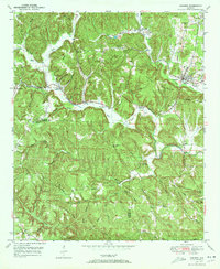 1949 Oakman1972 Print · USGSThe Walker County coal and rail landscape comes alive in this post-war survey of the Oakman area. Researchers can trace the SOUTHERN railroad through the hills to locate Coal Valley, the Patton Hill Fire Tower, and local landmarks like Infant Hill Cemetery.2 unique versions available
 - 1949 Map of Wiley, 1973 Print
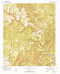 1949 Wiley1973 Print · USGSThe rural borderlands of Fayette, Walker, and Tuscaloosa Counties are captured here in the late 1940s just as the regional landscape was maturing. Genealogists can trace family roots through landmarks like Brandon Sch, Flatwoods Cem, and Rock Springs Ch.3 unique versions available
End of results
Showing maps 1-2 of 2
Top cities of Fayette County
Frequently asked questions
- What are the different types of historical maps available for Fayette County?
- What is the oldest map of Fayette County?
- Where can I purchase historical maps of Fayette County for my home or office?
- Where can I download high-res historical maps of Fayette County?
- Are there historical topographic maps available for Fayette County?
- Is there historical aerial imagery available for Fayette County?
- Where are historical maps of Fayette County sourced from?