1930s Maps of Russellville, Alabama
Explore 4 historic maps of Russellville from the 1930s. These maps offer a rare glimpse into what life looked like during the 1930s — showing old roads, neighborhoods, homes, and landmarks that have changed or disappeared over time.
Whether you're researching your family's past, planning a metal detecting trip, or studying how Russellville's landscape evolved across the 1930s, these high-resolution maps are a powerful tool for exploring the history of this region.
- Focus on a specific era: All maps on this page are from the 1930s, giving you a focused view of this time period.
- See what’s changed: Compare century-old streets, trails, and buildings to today's modern landscape using overlays and satellite layers.
- Research with precision: Use these maps for genealogy, historical research, land use analysis, or educational projects.
- View, download, or print: Maps are fully viewable online in high resolution, and can be downloaded or printed for your own records.
Start exploring Russellville's history through authentic maps from the 1930s. This is your window into the past.
Russellville, AL maps
(4)- 1936 Map of Russellville
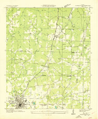 1936 Russellville1936 Print · USGSFranklin County in the mid-1930s shows a landscape of small agricultural settlements and nascent industrial infrastructure along the Southern Railway. Genealogists can trace family landmarks and schools like Mountain Star Sch, the Iron Mine (Abandoned), and Osborn Cem.
 - 1936 Map of Frankfort
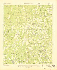 1936 Frankfort1936 Print · USGSNorthwest Alabama in the mid-1930s reveals a patchwork of small creek-side settlements and rural schools along the Chickasaw Boundary. Researchers can trace old family sites and crossroads like Frankfort, Hovaters Mill, and the Burnt Church Cem.
 - 1936 Map of Isbell
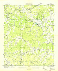 1936 Isbell1936 Print · USGSFranklin County's rural landscape is captured here in the mid-1930s as the Tennessee Valley Authority began its regional work. Researchers can trace family history through numerous landmarks including Marmon Cem, Pleasant Hill Sch, and the Old Chickasaw Bdy.
 - 1936 Map of Spruce Pine
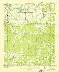 1936 Spruce Pine1936 Print · USGSFranklin County enters a period of modern transformation in the mid-1930s as federal projects and industry reshape the land. Genealogists can trace family footprints at Sloss Chapel, Enterprise Sch, and the Sargent Cem near the town of Waco.
End of results
Showing maps 1-4 of 4
Top cities near Russellville
- Muscle Shoals historical maps
- Tuscumbia historical maps
- Haleyville historical maps
- Hackleburg historical maps
- Bear Creek historical maps
- Littleville historical maps
See more
Top neighborhoods of Russellville
- Woodlawn Heights historical maps
- Hester Heights historical maps
- Reedtown historical maps
- Russellville Commercial Historic District historical maps
Frequently asked questions
- What are the different types of historical maps available for Russellville?
- What is the oldest map of Russellville?
- Where can I purchase historical maps of Russellville for my home or office?
- Where can I download high-res historical maps of Russellville?
- Are there historical topographic maps available for Russellville?
- Is there historical aerial imagery available for Russellville?
- Where are historical maps of Russellville sourced from?