1950s Maps of Russellville, Alabama
Explore 4 historic maps of Russellville from the 1950s. These maps offer a rare glimpse into what life looked like during the 1950s — showing old roads, neighborhoods, homes, and landmarks that have changed or disappeared over time.
Whether you're researching your family's past, planning a metal detecting trip, or studying how Russellville's landscape evolved across the 1950s, these high-resolution maps are a powerful tool for exploring the history of this region.
- Focus on a specific era: All maps on this page are from the 1950s, giving you a focused view of this time period.
- See what’s changed: Compare century-old streets, trails, and buildings to today's modern landscape using overlays and satellite layers.
- Research with precision: Use these maps for genealogy, historical research, land use analysis, or educational projects.
- View, download, or print: Maps are fully viewable online in high resolution, and can be downloaded or printed for your own records.
Start exploring Russellville's history through authentic maps from the 1950s. This is your window into the past.
Russellville, AL maps
(4)- 1956 Map of Gadsden, 1966 Print
 1956 Gadsden1966 Print · USGSNorth Alabama in the mid-1950s shows a region transformed by river engineering and federal industry. Genealogists and local historians can trace the development of the Tennessee Valley through the growth of Huntsville, the sprawling Redstone Arsenal, and the expansive Guntersville Lake.3 unique versions available
 - 1957 Map of Russellville, 1958 Print
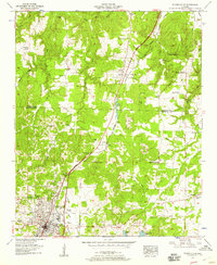 1957 Russellville1958 Print · USGSMid-century Franklin County comes to life as the industrial and transit hub of North Alabama. Genealogists and researchers can trace local families through many sites like Young Cemetery and Wesley Memorial Church or locate the old Russellville Landing Field.
 - 1957 Map of Frankfort, 1958 Print
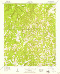 1957 Frankfort1958 Print · USGSAlabama's western hills come into focus in the late 1950s as a landscape of isolated farmsteads and rural congregations. Trace local family history through landmarks like Crooked Oak, Jonesboro Ch, and the Malone Cem.3 unique versions available
 - 1958 Map of Gadsden
 1958 Gadsden1958 Print · USGSNorth Alabama comes alive in the late 1950s as the Tennessee Valley Authority’s massive river projects and the rise of the space industry reshaped the landscape. Researchers can trace the mid-century footprints of Huntsville, Redstone Arsenal, and the riverside rail networks of the Southern railroad.
End of results
Showing maps 1-4 of 4
Top cities near Russellville
- Muscle Shoals historical maps
- Tuscumbia historical maps
- Haleyville historical maps
- Hackleburg historical maps
- Bear Creek historical maps
- Littleville historical maps
See more
Top neighborhoods of Russellville
- Woodlawn Heights historical maps
- Hester Heights historical maps
- Reedtown historical maps
- Russellville Commercial Historic District historical maps
Frequently asked questions
- What are the different types of historical maps available for Russellville?
- What is the oldest map of Russellville?
- Where can I purchase historical maps of Russellville for my home or office?
- Where can I download high-res historical maps of Russellville?
- Are there historical topographic maps available for Russellville?
- Is there historical aerial imagery available for Russellville?
- Where are historical maps of Russellville sourced from?