1960s Maps of Geneva County, Alabama
Explore 8 historic maps of Geneva County from the 1960s. These maps offer a rare glimpse into what life looked like during the 1960s — showing old roads, neighborhoods, homes, and landmarks that have changed or disappeared over time.
Whether you're researching your family's past, planning a metal detecting trip, or studying how Geneva County's landscape evolved across the 1960s, these high-resolution maps are a powerful tool for exploring the history of this region.
- Focus on a specific era: All maps on this page are from the 1960s, giving you a focused view of this time period.
- See what’s changed: Compare century-old streets, trails, and buildings to today's modern landscape using overlays and satellite layers.
- Research with precision: Use these maps for genealogy, historical research, land use analysis, or educational projects.
- View, download, or print: Maps are fully viewable online in high resolution, and can be downloaded or printed for your own records.
Start exploring Geneva County's history through authentic maps from the 1960s. This is your window into the past.
Geneva County, AL maps
(8)- 1960 Map of Pensacola
 1960 Pensacola1960 Print · USGSThe Florida Panhandle and Alabama's eastern shore are shown during a period of rapid military and coastal growth. Genealogists and historians can trace the mid-century footprints of Warrington, the Pensacola NAS (Chevalier), and the Blackwater River timber lands.
 - 1960 Map of Tallahassee
 1960 Tallahassee1960 Print · USGSThe Florida Panhandle and southern Georgia are captured here in the mid-twentieth century, showing a region defined by its rivers and military installations. Genealogists and historians can trace the growth of Tallahassee or locate coastal landmarks like the St Marks Lighthouse and Tyndall Air Force Base.
 - 1968 Map of Samson, 1970 Print
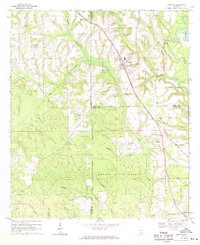
 1968 Samson1970 Print · USGSGeneva County life in the late sixties centers on the railroad hub of Samson and the fertile bottomlands of the PEA RIVER. Local researchers can locate family landmarks like Hall and Rivers Cem, the Drive-in Theater, and Oak Ridge Ch.2 unique versions available
 - 1968 Map of Sellersville, 1971 Print
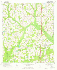
 1968 Sellersville1971 Print · USGSSoutheast Alabama’s agricultural heartland is documented here in the late sixties, showcasing the rural landscape at the border of Coffee and Geneva counties. Genealogists can trace family roots through landmarks like Weeks Cem, Friendship Ch, and the small settlement of Sellersville.2 unique versions available
 - 1969 Map of Dothan West, 1971 Print
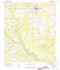
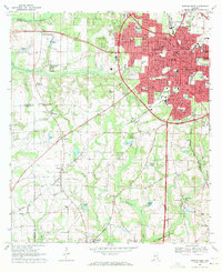 1969 Dothan West1971 Print · USGSDothan and its surrounding crossroads are captured here during a period of significant regional expansion in the late sixties. Researchers can trace historic schools and cemeteries such as Rehobeth High Sch, Carver High Sch, and Mt Zion Cem across the Wiregrass landscape.2 unique versions available
 - 1969 Map of Hacoda, 1971 Print
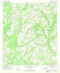
 1969 Hacoda1971 Print · USGSThe borderlands of Covington and Geneva counties come into focus in the late 1960s, showing a landscape of state forests and quiet settlements. Researchers can trace the Old Railroad Grade or locate family sites like Smyrna Church and Finks Millpond.
 - 1969 Map of Kinston, 1971 Print
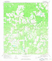
 1969 Kinston1971 Print · USGSSoutheast Alabama is captured here in the late sixties, showcasing the interplay between the Louisville and Nashville rail line and the deep timberlands of the Geneva State Forest. Researchers can locate old crossroads and family sites like Earlytown, St Pauls Cem, and Fine Level Ch.2 unique versions available
 - 1969 Map of Madrid, 1972 Print
 1969 Madrid1972 Print · USGSSoutheastern Alabama's rural landscape comes into focus here during the late sixties as the region’s agricultural and rail patterns remained firmly established. Genealogists can trace family footprints near Madrid and rural church sites like Mt Enon Ch or New Hope Ch.2 unique versions available
End of results
Showing maps 1-8 of 8
Top cities of Geneva County
- Geneva historical maps
- Hartford historical maps
- Slocomb historical maps
- Samson historical maps
- Malvern historical maps
- Eunola historical maps
See more
Frequently asked questions
- What are the different types of historical maps available for Geneva County?
- What is the oldest map of Geneva County?
- Where can I purchase historical maps of Geneva County for my home or office?
- Where can I download high-res historical maps of Geneva County?
- Are there historical topographic maps available for Geneva County?
- Is there historical aerial imagery available for Geneva County?
- Where are historical maps of Geneva County sourced from?