1980s Maps of Geneva County, Alabama
Explore 9 historic maps of Geneva County from the 1980s. These maps offer a rare glimpse into what life looked like during the 1980s — showing old roads, neighborhoods, homes, and landmarks that have changed or disappeared over time.
Whether you're researching your family's past, planning a metal detecting trip, or studying how Geneva County's landscape evolved across the 1980s, these high-resolution maps are a powerful tool for exploring the history of this region.
- Focus on a specific era: All maps on this page are from the 1980s, giving you a focused view of this time period.
- See what’s changed: Compare century-old streets, trails, and buildings to today's modern landscape using overlays and satellite layers.
- Research with precision: Use these maps for genealogy, historical research, land use analysis, or educational projects.
- View, download, or print: Maps are fully viewable online in high resolution, and can be downloaded or printed for your own records.
Start exploring Geneva County's history through authentic maps from the 1980s. This is your window into the past.
Geneva County, AL maps
(9)- 1981 Map of Dothan, 1982 Print
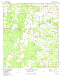
 1981 Dothan1982 Print · USGSSoutheast Alabama and the tri-state border region are shown here in the early 1980s as the area thrived on military and rail connectivity. Researchers can trace historic transit lines like the Hartford and Slocomb railroad or locate family roots in Ozark, Headland, and Geneva.
 - 1982 Map of Campbellton
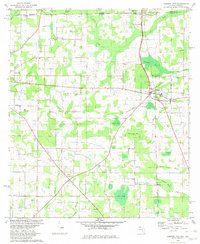 1982 Campbellton1982 Print · USGSJackson County and the Florida-Alabama border appear here in the early eighties as a landscape of crossroads settlements and small-town junctions. Genealogists can trace family landmarks like Hinson Cem and Salem Ch along the Atlanta and Saint Andrews Bay rail line.2 unique versions available
 - 1982 Map of Hobbs Crossroads
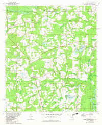 1982 Hobbs Crossroads1982 Print · USGSThe Florida-Alabama borderlands along the Pea River are captured here in the early eighties, showing a landscape of bay galls and rural settlements. Trace family roots at Sweet Gum Head Cemeteries or explore the river landings at Old Warehouse Landing.3 unique versions available
 - 1982 Map of Esto, 1983 Print
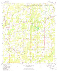 1982 Esto1983 Print · USGSThe Florida-Alabama state line and the Holmes County border intersect here in the early eighties, anchoring a landscape of rural crossroads and cypress bays. Researchers can trace family history at the Bethlehem-West Florida Camp Meeting Ground and old burial sites like Double Springs Cem.2 unique versions available
 - 1982 Map of Graceville, 1983 Print
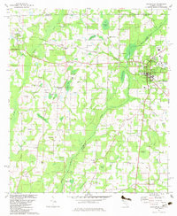 1982 Graceville1983 Print · USGSThe Florida-Alabama borderlands come into focus in the early eighties, showcasing the agricultural and rail-oriented landscape around Graceville. Genealogists and historians can trace community roots at Cem Liberty Hill Ch, Damascus Ch, and the site of Collins Mill.2 unique versions available
 - 1982 Map of Izagora, 1983 Print
 1982 Izagora1983 Print · USGSThe Florida-Alabama borderlands near the Choctawhatchee River come into focus in the early eighties, showing a landscape of scattered rural settlements and winding creeks. Genealogists can trace family roots at Izagora, Smith Crossroads, and several local landmarks like Midway Ch and Curry Cem.2 unique versions available
 - 1986 Map of Andalusia
 1986 Andalusia1986 Print · USGSCovington County and the Wiregrass region are shown here in the mid-1980s, centered on the growing hubs of Andalusia and Opp. Genealogists and local historians can trace legacy sites like the Old Pioneer Cem, Straughn Sch, and the rail lines of the Louisville and Nashville RR.2 unique versions available
 - 1987 Map of Darlington, 1993 Print
 1987 Darlington1993 Print · USGSIn the late twentieth century, this North Florida borderland was a patchwork of small communities and family-named cemeteries. Researchers can trace rural settlement patterns through sites like the Limestone Cem, the village of Darlington, and the wetlands of Peavey Bay.
 - 1988 Map of Tallahassee
 1988 Tallahassee1988 Print · USGSThe Florida Panhandle and South Georgia are captured here in the late eighties, showing the expansion of the regional highway network and coastal growth. Genealogists and historians can trace rail lines like the Seaboard System Railroad or locate family roots in Blountstown, Graceville, or Crawfordville.2 unique versions available
End of results
Showing maps 1-9 of 9
Top cities of Geneva County
- Geneva historical maps
- Hartford historical maps
- Slocomb historical maps
- Samson historical maps
- Malvern historical maps
- Eunola historical maps
See more
Frequently asked questions
- What are the different types of historical maps available for Geneva County?
- What is the oldest map of Geneva County?
- Where can I purchase historical maps of Geneva County for my home or office?
- Where can I download high-res historical maps of Geneva County?
- Are there historical topographic maps available for Geneva County?
- Is there historical aerial imagery available for Geneva County?
- Where are historical maps of Geneva County sourced from?