1940s Maps of Geneva County, Alabama
Explore 3 historic maps of Geneva County from the 1940s. These maps offer a rare glimpse into what life looked like during the 1940s — showing old roads, neighborhoods, homes, and landmarks that have changed or disappeared over time.
Whether you're researching your family's past, planning a metal detecting trip, or studying how Geneva County's landscape evolved across the 1940s, these high-resolution maps are a powerful tool for exploring the history of this region.
- Focus on a specific era: All maps on this page are from the 1940s, giving you a focused view of this time period.
- See what’s changed: Compare century-old streets, trails, and buildings to today's modern landscape using overlays and satellite layers.
- Research with precision: Use these maps for genealogy, historical research, land use analysis, or educational projects.
- View, download, or print: Maps are fully viewable online in high resolution, and can be downloaded or printed for your own records.
Start exploring Geneva County's history through authentic maps from the 1940s. This is your window into the past.
Geneva County, AL maps
(3)- 1942 Map of Enterprise
 1942 Enterprise1942 Print · USGSSoutheast Alabama is shown at a wartime turning point, just as Camp Rucker was established. Family historians can trace hundreds of rural landmarks, from Oak Grove Ch & Sch to the New Prospect Ch.
 - 1949 Map of Glendale
 1949 Glendale1949 Print · USGSNorthern Walton County in the late 1940s reveals a landscape of isolated turpentine stills and rural congregations. Trace family roots at Halls Still, Darlington, and Limestone Cem while exploring the wetlands of Big Swamp.
 - 1949 Map of Hobbs Crossroads, 1973 Print
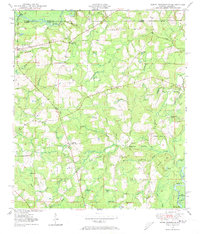 1949 Hobbs Crossroads1973 Print · USGSThe Alabama-Florida state line meets in the late 1940s near rural hubs and bayous. Researchers can trace family sites like McDuffie Cem and find old gathering places like Barker Store or the Poplar Head Ch.
End of results
Showing maps 1-3 of 3
Top cities of Geneva County
- Geneva historical maps
- Hartford historical maps
- Slocomb historical maps
- Samson historical maps
- Malvern historical maps
- Eunola historical maps
See more
Frequently asked questions
- What are the different types of historical maps available for Geneva County?
- What is the oldest map of Geneva County?
- Where can I purchase historical maps of Geneva County for my home or office?
- Where can I download high-res historical maps of Geneva County?
- Are there historical topographic maps available for Geneva County?
- Is there historical aerial imagery available for Geneva County?
- Where are historical maps of Geneva County sourced from?