1940s Maps of Greene County, Alabama
Explore 8 historic maps of Greene County from the 1940s. These maps offer a rare glimpse into what life looked like during the 1940s — showing old roads, neighborhoods, homes, and landmarks that have changed or disappeared over time.
Whether you're researching your family's past, planning a metal detecting trip, or studying how Greene County's landscape evolved across the 1940s, these high-resolution maps are a powerful tool for exploring the history of this region.
- Focus on a specific era: All maps on this page are from the 1940s, giving you a focused view of this time period.
- See what’s changed: Compare century-old streets, trails, and buildings to today's modern landscape using overlays and satellite layers.
- Research with precision: Use these maps for genealogy, historical research, land use analysis, or educational projects.
- View, download, or print: Maps are fully viewable online in high resolution, and can be downloaded or printed for your own records.
Start exploring Greene County's history through authentic maps from the 1940s. This is your window into the past.
Greene County, AL maps
(8)- 1946 Map of Demopolis, 1947 Print
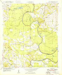
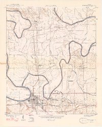 1946 Demopolis1947 Print · USGSDemopolis and its surrounding river bends are captured here in the mid-1940s, showing a landscape defined by the Tombigbee and Black Warrior rivers. Genealogists and historians can trace community roots through numerous local landmarks like Jerusalem Ch, Birdine Junior High Sch, and Merriwether Ferry.3 unique versions available
 - 1947 Map of Demopolis
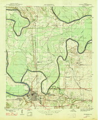 1947 Demopolis1947 Print · USGSDemopolis and its surroundings were defined by the convergence of major rivers and railroads in the late 1940s. Genealogists and historians can trace community life through sites like the Rosenwald Sch, the Arington Cem, and landmarks such as Merriwether Ferry.
 - 1947 Map of Mason Bend, 1948 Print
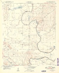 1947 Mason Bend1948 Print · USGSThe Black Warrior River winds through Greene and Hale counties in the late 1940s, defining a landscape of deep oxbows and rural quarters. Researchers can trace local genealogy through several school sites like Loyss Sch and family landmarks such as Walden Quarters and Creehill Cem.2 unique versions available
 - 1947 Map of Forkland, 1973 Print
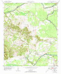
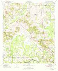 1947 Forkland1973 Print · USGSGreene County, Alabama, is documented here in the mid-1940s as the river-and-rail economy shaped local life. Researchers can trace family roots through numerous rural landmarks like Hard Bargain Cem, Thornhill Sta, and the Stonewall Taylor Sch.3 unique versions available
 - 1948 Map of Mason Bend
 1948 Mason Bend1948 Print · USGSThe Black Warrior River winds through Greene and Hale counties in the late 1940s, revealing a landscape of river-bend settlements and labor quarters. Genealogists and historians can trace the locations of Ebenezer Sch, Walden Quarters, and Lock No 6.
 - 1948 Map of Mc Dowell, 1973 Print
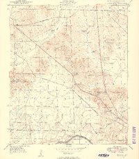
 1948 Mc Dowell1973 Print · USGSSumter and Greene Counties are defined by the winding river and its early crossings in the late 1940s. Genealogists and historians can trace the foundations of rural life through landmarks like McDowell Ferry, Belmont Ch, and the Taylor Cem.3 unique versions available
 - 1949 Map of Mc Dowell
 1949 Mc Dowell1949 Print · USGSSumter County in the late 1940s is defined by its deep relationship with the winding Tombigbee River. Genealogists and historians can trace family roots through numerous local landmarks like Bucks Chapel Sch, Belmont Ch, and the historic McDowell Ferry.2 unique versions available
 - 1949 Map of Forkland
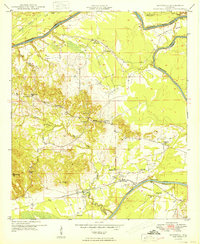
 1949 Forkland1949 Print · USGSGreene County near the Tombigbee River in the late 1940s reveals a landscape of small schools and family-named landmarks. Trace the ST LOUIS SAN FRANCISCO rail line past Thornhill Sta or locate burial sites like Hard Bargain Cem.2 unique versions available
End of results
Showing maps 1-8 of 8
Top cities of Greene County
Frequently asked questions
- What are the different types of historical maps available for Greene County?
- What is the oldest map of Greene County?
- Where can I purchase historical maps of Greene County for my home or office?
- Where can I download high-res historical maps of Greene County?
- Are there historical topographic maps available for Greene County?
- Is there historical aerial imagery available for Greene County?
- Where are historical maps of Greene County sourced from?