1980s Maps of Greene County, Alabama
Explore 11 historic maps of Greene County from the 1980s. These maps offer a rare glimpse into what life looked like during the 1980s — showing old roads, neighborhoods, homes, and landmarks that have changed or disappeared over time.
Whether you're researching your family's past, planning a metal detecting trip, or studying how Greene County's landscape evolved across the 1980s, these high-resolution maps are a powerful tool for exploring the history of this region.
- Focus on a specific era: All maps on this page are from the 1980s, giving you a focused view of this time period.
- See what’s changed: Compare century-old streets, trails, and buildings to today's modern landscape using overlays and satellite layers.
- Research with precision: Use these maps for genealogy, historical research, land use analysis, or educational projects.
- View, download, or print: Maps are fully viewable online in high resolution, and can be downloaded or printed for your own records.
Start exploring Greene County's history through authentic maps from the 1980s. This is your window into the past.
Greene County, AL maps
(11)- 1980 Map of Union
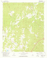 1980 Union1980 Print · USGSGreene County, Alabama, is shown in the late 1970s as a landscape of small rural settlements and family landmarks. Researchers can locate dozens of country churches and burial sites like Birdine Hill Ch, Eatman Sch, and Spencer Cem among the winding bends of Trussells Creek.
 - 1980 Map of Casemore
 1980 Casemore1980 Print · USGSHale County's fertile Black Belt region is captured here in the 1980s, defined by the winding Black Warrior River and a dense network of rural communities. Researchers can trace local heritage through numerous landmarks like St Andrews Ch, Lock 5, and the old settlement of Prairieville.4 unique versions available
 - 1980 Map of Moundville West
 1980 Moundville West1980 Print · USGSThe Black Warrior River and Southern Railway define this Hale County landscape during the late twentieth century. Genealogists can trace family names at Taylor Chapel, Havana Cem, and small settlements like Powers and Guinea.
 - 1980 Map of Eutaw
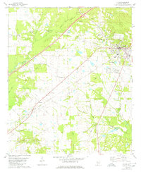 1980 Eutaw1980 Print · USGSThe county seat of Eutaw is captured here in the late twentieth century, showing a landscape defined by traditional rural settlements and rising infrastructure. Genealogists can trace family lands near Pippen Lawn Cem, Bethlehem Ch, and Allison.2 unique versions available
 - 1980 Map of Warrior Dam
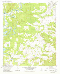
 1980 Warrior Dam1980 Print · USGSThe Black Warrior River winding through Greene and Hale Counties is shown here in the late seventies just as the modern lock system was well-established. Researchers can trace river landings and family sites like Finches Ferry, Wedgeworth, and Grimm Chapel.
 - 1980 Map of Knoxville
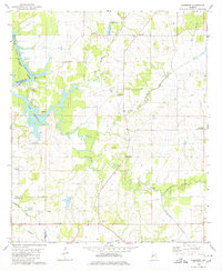
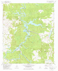
 1980 Knoxville1980 Print · USGSGreene and Hale counties meet along the winding river and lakefront during the early 1980s. Genealogists can trace family footprints through numerous rural churches like New Bethany Ch and the riverside settlement of Oak Village.
 - 1980 Map of Melton
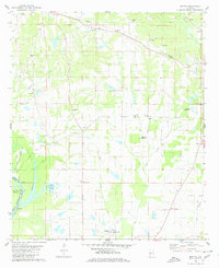 1980 Melton1980 Print · USGSHale County, Alabama, is documented here in the early eighties as the Black Warrior River floodplain meets the interior hills. Genealogists and historians can trace numerous rural burial grounds like Boston Cem and Ramey Cem or locate the State Penal Farm.2 unique versions available
 - 1984 Map of De Kalb
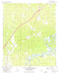
 1984 De Kalb1984 Print · USGSThe Mississippi-Alabama borderlands come into focus in the 1980s, where the river-and-rail economy meets military and tribal lands. Researchers can trace rural lineages across the Choctaw Indian Reservation or through the rail towns of Scooba and De Kalb.2 unique versions available
 - 1984 Map of West Point
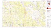
 1984 West Point1984 Print · USGSNorth-Central Mississippi in the mid-eighties shows a landscape defined by massive water management projects and dense timberlands. Researchers can trace the legacy of rural settlements like Geeslin Corner or the rail corridors of the Illinois Central Gulf RR near Grenada Lake.3 unique versions available
 - 1984 Map of Tuscaloosa, 1985 Print
 1984 Tuscaloosa1985 Print · USGSWest-central Alabama centers on the mid-1980s expansion of the university and the river economy. Genealogists and historians can trace small-town connections through Burchfield Store, North Johns, and the rail lines of the Southern railroad.2 unique versions available
 - 1986 Map of Demopolis
 1986 Demopolis1986 Print · USGSWest-central Alabama's river-and-rail corridors are preserved here in the mid-eighties, showing the deep-seated settlement patterns of the Black Belt. Genealogists and historians can locate family-named landmarks like Crenshaw Quarters or industrial sites including Cleveland Mills and the Warrior Lock and Dam.
End of results
Showing maps 1-11 of 11
Top cities of Greene County
Frequently asked questions
- What are the different types of historical maps available for Greene County?
- What is the oldest map of Greene County?
- Where can I purchase historical maps of Greene County for my home or office?
- Where can I download high-res historical maps of Greene County?
- Are there historical topographic maps available for Greene County?
- Is there historical aerial imagery available for Greene County?
- Where are historical maps of Greene County sourced from?