1980s Maps of Bessemer, Alabama
Explore 3 historic maps of Bessemer from the 1980s. These maps offer a rare glimpse into what life looked like during the 1980s — showing old roads, neighborhoods, homes, and landmarks that have changed or disappeared over time.
Whether you're researching your family's past, planning a metal detecting trip, or studying how Bessemer's landscape evolved across the 1980s, these high-resolution maps are a powerful tool for exploring the history of this region.
- Focus on a specific era: All maps on this page are from the 1980s, giving you a focused view of this time period.
- See what’s changed: Compare century-old streets, trails, and buildings to today's modern landscape using overlays and satellite layers.
- Research with precision: Use these maps for genealogy, historical research, land use analysis, or educational projects.
- View, download, or print: Maps are fully viewable online in high resolution, and can be downloaded or printed for your own records.
Start exploring Bessemer's history through authentic maps from the 1980s. This is your window into the past.
Bessemer, AL maps
(3)- 1980 Map of Mc Calla
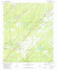 1980 Mc Calla1980 Print · USGSThe industrial corridor southwest of Birmingham appears in the 1980s as a complex landscape of coal mining and ridge-and-valley settlements. Genealogists and local historians can trace family roots through McCalla, North Johns, and several landmarks like Ligon Cem and the McAdory High Sch.2 unique versions available
 - 1984 Map of Tuscaloosa, 1985 Print
 1984 Tuscaloosa1985 Print · USGSWest-central Alabama centers on the mid-1980s expansion of the university and the river economy. Genealogists and historians can trace small-town connections through Burchfield Store, North Johns, and the rail lines of the Southern railroad.2 unique versions available
 - 1984 Map of Birmingham South, 1985 Print
 1984 Birmingham South1985 Print · USGSThe Birmingham metropolitan region and the Coosa River valley are shown here in the mid-eighties as suburban growth expanded south into the ridges. Genealogists and local historians can trace the development of communities from Bessemer to Sylacauga alongside the Lay Lake shoreline and the Talladega National Forest.2 unique versions available
End of results
Showing maps 1-3 of 3
Top cities near Bessemer
- Birmingham historical maps
- Hoover historical maps
- Hoover historical maps
- Vestavia Hills historical maps
- Alabaster historical maps
- Homewood historical maps
See more
Top neighborhoods of Bessemer
- Hilltop historical maps
- Hopewell historical maps
- McAdory historical maps
- Morgan historical maps
- Chinn historical maps
- Parkwood historical maps
See more
Frequently asked questions
- What are the different types of historical maps available for Bessemer?
- What is the oldest map of Bessemer?
- Where can I purchase historical maps of Bessemer for my home or office?
- Where can I download high-res historical maps of Bessemer?
- Are there historical topographic maps available for Bessemer?
- Is there historical aerial imagery available for Bessemer?
- Where are historical maps of Bessemer sourced from?