1970s Maps of Bessemer, Alabama
Explore 6 historic maps of Bessemer from the 1970s. These maps offer a rare glimpse into what life looked like during the 1970s — showing old roads, neighborhoods, homes, and landmarks that have changed or disappeared over time.
Whether you're researching your family's past, planning a metal detecting trip, or studying how Bessemer's landscape evolved across the 1970s, these high-resolution maps are a powerful tool for exploring the history of this region.
- Focus on a specific era: All maps on this page are from the 1970s, giving you a focused view of this time period.
- See what’s changed: Compare century-old streets, trails, and buildings to today's modern landscape using overlays and satellite layers.
- Research with precision: Use these maps for genealogy, historical research, land use analysis, or educational projects.
- View, download, or print: Maps are fully viewable online in high resolution, and can be downloaded or printed for your own records.
Start exploring Bessemer's history through authentic maps from the 1970s. This is your window into the past.
Bessemer, AL maps
(6)- 1975 Map of Yolande NE, 1977 Print
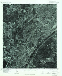
 1975 Yolande NE1977 Print · USGSJefferson County’s industrial and residential fringes come into sharp focus in the mid-1970s. Researchers can trace the development of Hueytown and Virginia, or follow the winding path of Valley Creek through the wooded hills.
 - 1975 Map of Helena, 1977 Print
 1975 Helena1977 Print · USGSShelby County emerges in the mid-seventies in this aerial survey, showing the landscape just as suburban growth began to take hold. Researchers can trace the original footprint of Helena and follow the winding course of the Cahaba River.
 - 1975 Map of Yolande SE, 1977 Print
 1975 Yolande SE1977 Print · USGSJefferson County in the mid-1970s is shown in this detailed orthophoto as industrial patterns and rural settlements meet. Genealogists and local historians can trace the clear physical footprints of Mc Calla, Baylor, and Kimbrell.
 - 1975 Map of Greenwood, 1977 Print
 1975 Greenwood1977 Print · USGSJefferson County residential and industrial clearings are captured during the mid-seventies in this detailed aerial orthophoto. Researchers can trace the development of Greenwood and Parkwood or follow the winding path of the Cahaba River.
 - 1975 Map of Bessemer, 1977 Print
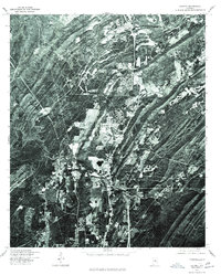
 1975 Bessemer1977 Print · USGSBessemer and the Birmingham industrial corridor are shown in sharp detail during the mid-seventies in this rectified aerial survey. Local historians can trace the physical footprints of Bessemer, Hueytown, and Pleasant Grove as they appeared decades ago.
 - 1979 Map of Concord, 1980 Print
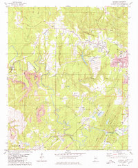 1979 Concord1980 Print · USGSSouthwest of Birmingham in the late 1970s, this area shows a landscape shaped by coal and community. Genealogists can trace family roots at Old Shady Grove Ch, Valley Creek Cem, or the namesake Concord Mine.2 unique versions available
End of results
Showing maps 1-6 of 6
Top cities near Bessemer
- Birmingham historical maps
- Hoover historical maps
- Hoover historical maps
- Vestavia Hills historical maps
- Alabaster historical maps
- Homewood historical maps
See more
Top neighborhoods of Bessemer
- Hilltop historical maps
- Hopewell historical maps
- McAdory historical maps
- Morgan historical maps
- Chinn historical maps
- Parkwood historical maps
See more
Frequently asked questions
- What are the different types of historical maps available for Bessemer?
- What is the oldest map of Bessemer?
- Where can I purchase historical maps of Bessemer for my home or office?
- Where can I download high-res historical maps of Bessemer?
- Are there historical topographic maps available for Bessemer?
- Is there historical aerial imagery available for Bessemer?
- Where are historical maps of Bessemer sourced from?