1920s Maps of Lauderdale County, Alabama
Explore 7 historic maps of Lauderdale County from the 1920s. These maps offer a rare glimpse into what life looked like during the 1920s — showing old roads, neighborhoods, homes, and landmarks that have changed or disappeared over time.
Whether you're researching your family's past, planning a metal detecting trip, or studying how Lauderdale County's landscape evolved across the 1920s, these high-resolution maps are a powerful tool for exploring the history of this region.
- Focus on a specific era: All maps on this page are from the 1920s, giving you a focused view of this time period.
- See what’s changed: Compare century-old streets, trails, and buildings to today's modern landscape using overlays and satellite layers.
- Research with precision: Use these maps for genealogy, historical research, land use analysis, or educational projects.
- View, download, or print: Maps are fully viewable online in high resolution, and can be downloaded or printed for your own records.
Start exploring Lauderdale County's history through authentic maps from the 1920s. This is your window into the past.
Lauderdale County, AL maps
(7)- 1924 Map of Tuscumbia
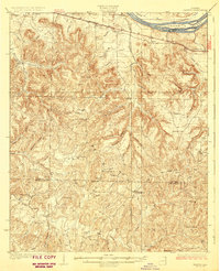
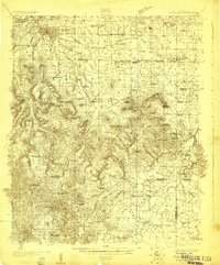 1924 Tuscumbia1924 Print · USGSNorth Alabama in the mid-twenties shows a landscape of river-oriented commerce and upland farming before the modern reservoir system. Genealogists can locate family landmarks from Leighton to Russellville, including Clements Mill, Ligon Springs, and the Morning Star School.2 unique versions available
 - 1924 Map of Gravelly Springs
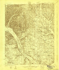 1924 Gravelly Springs1924 Print · USGSLauderdale County at the edge of the Tennessee River reveals a vibrant rural society in the mid-twenties, centered on the river and the rail line. Researchers can trace the heritage of vanished landmarks like Lyle Academy, the Colbert Shoals Canal, and the Oakland School (Colored).2 unique versions available
 - 1925 Map of Barton, 1954 Print
 1925 Barton1954 Print · USGSColbert and Franklin Counties are captured here in the mid-twenties, showing a landscape of river-valley agriculture and rugged uplands. Researchers can locate dozens of rural landmarks, from the rail stop at Barton to country schools like Whiteoak Sch and Jonesboro Sch.
 - 1926 Map of Tuscumbia
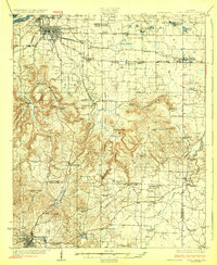 1926 Tuscumbia1926 Print · USGSThe Tennessee River valley and the northern ridges of the Black Warrior highlands appear here in the mid-twenties. Genealogists can trace family sites like Campbell Settlement or early centers such as Spring Valley Sta and Atepost.3 unique versions available
 - 1926 Map of Barton
 1926 Barton1926 Print · USGSNorthwest Alabama's river hills and rail corridors come alive in this mid-twenties survey of Colbert and Franklin Counties. Genealogists can trace family roots through numerous local landmarks like Evening Shade Church, Back Creek School, and the settlement at Frankfort.
 - 1926 Map of Gravelly Springs
 1926 Gravelly Springs1926 Print · USGSNorthwest Alabama is seen here in the mid-twenties, when the river and rail lines dictated the rhythm of Lauderdale and Colbert counties. Genealogists can locate family landmarks like Lyle Academy, Youngs Store, and the Colbert Shoals Canal.2 unique versions available
 - 1929 Map of Barton
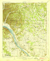
 1929 Barton1929 Print · USGSIn the late 1920s, this area of Northwest Alabama was a patchwork of creek-side farms and small railroad stops. Researchers can trace the layout of early rural life through community hubs like Barton, Crooked Oak, and the Evening Shade Ch school and church.3 unique versions available
End of results
Showing maps 1-7 of 7
Top cities of Lauderdale County
- Florence historical maps
- Underwood-Petersville historical maps
- Rogersville historical maps
- Killen historical maps
- Lexington historical maps
- Saint Florian historical maps
See more
Frequently asked questions
- What are the different types of historical maps available for Lauderdale County?
- What is the oldest map of Lauderdale County?
- Where can I purchase historical maps of Lauderdale County for my home or office?
- Where can I download high-res historical maps of Lauderdale County?
- Are there historical topographic maps available for Lauderdale County?
- Is there historical aerial imagery available for Lauderdale County?
- Where are historical maps of Lauderdale County sourced from?