1930s Maps of Lauderdale County, Alabama
Explore 25 historic maps of Lauderdale County from the 1930s. These maps offer a rare glimpse into what life looked like during the 1930s — showing old roads, neighborhoods, homes, and landmarks that have changed or disappeared over time.
Whether you're researching your family's past, planning a metal detecting trip, or studying how Lauderdale County's landscape evolved across the 1930s, these high-resolution maps are a powerful tool for exploring the history of this region.
- Focus on a specific era: All maps on this page are from the 1930s, giving you a focused view of this time period.
- See what’s changed: Compare century-old streets, trails, and buildings to today's modern landscape using overlays and satellite layers.
- Research with precision: Use these maps for genealogy, historical research, land use analysis, or educational projects.
- View, download, or print: Maps are fully viewable online in high resolution, and can be downloaded or printed for your own records.
Start exploring Lauderdale County's history through authentic maps from the 1930s. This is your window into the past.
Lauderdale County, AL maps
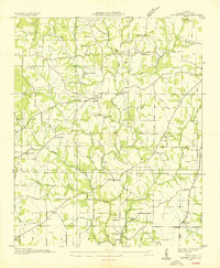
(25)- 1935 Map of Cherokee
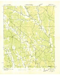
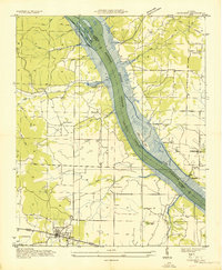 1935 Cherokee1935 Print · USGSNorthern Alabama is captured in the mid-1930s as the TVA prepares to inundate the valley for the Pickwick Landing Reservoir. Genealogists and historians can trace family-named sites like Perkins Cem, Moontown Ch, and the town of Cherokee.
 - 1935 Map of Wright
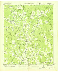
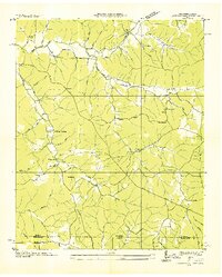
 1935 Wright1935 Print · USGSLauderdale County and the Tennessee River are shown here in the mid-1930s during the early development of the Tennessee Valley Authority. Genealogists can trace early landmarks such as Williams Chapel, Youngs Store, and the historic Nathez Trace.
 - 1936 Map of Waterloo
 1936 Waterloo1936 Print · USGSThe Tennessee River border between Alabama and Mississippi is captured here during the mid-1930s transition to a dammed waterway. Genealogists and historians can locate community landmarks like Fords Mill Ch, the Riverton Ferry, and Watkins Cem.
 - 1936 Map of Union Hill
 1936 Union Hill1936 Print · USGSThe Alabama and Tennessee borderlands are captured here in the mid-1930s as modern infrastructure arrived in a landscape of small family farms. Researchers can locate long-standing landmarks like Ridgeways Mill, Hester Cem, and the rural community of Good Springs.
 - 1936 Map of Thorntontown
 1936 Thorntontown1936 Print · USGSLauderdale County was undergoing a massive transformation in the mid-1930s as the Tennessee Valley Authority flooded the river basin. Researchers can trace the submerged geography of Former Islands or locate family sites like Fuqua Cem and Haraway Sch.
 - 1936 Map of Pride
 1936 Pride1936 Print · USGSColbert County sits at a crossroads of river and rail during the mid-1930s expansion of the TVA system. Genealogists and historians can trace family-named landmarks like Hesters Store and Kellar Quarry Landing alongside rural community hubs like Nazare Ch and Barton Sch.
 - 1936 Map of Light
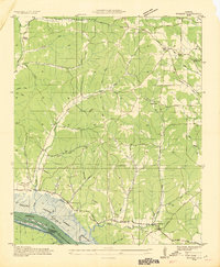
 1936 Light1936 Print · USGSThe borderlands of Tennessee and Alabama come alive in this mid-1930s survey of rural Wayne County. Researchers can trace the heritage of Pleasant Valley through its many landmarks like Friendship Sch, Oak Grove Ch, and Sweaney Sch.
 - 1936 Map of Lexington
 1936 Lexington1936 Print · USGSLauderdale County and the Tennessee state line appear here in the mid-1930s as rural life centered around small creek-side settlements. Genealogists can trace family landmarks like the Portertown Cemetery, Hammond School, and the local Ingram Mill.
 - 1936 Map of Shaws
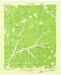
 1936 Shaws1936 Print · USGSThe Tennessee Valley was undergoing a massive transformation in the mid-1930s as the Pickwick Landing project reshaped the tri-state border. Genealogists and local historians can trace rural family-named sites like Hubbard Cem, Panther Creek Sch, and Beckman Landing.
 - 1936 Map of Threet
 1936 Threet1936 Print · USGSLauderdale County in the mid-1930s is revealed as a network of creek-side farmsteads and rural crossroads. Genealogists can locate family landmarks like Pine Hill Cem, Wesley Chapel, and the Burcham Valley Sch.
 - 1936 Map of Cypress Inn
 1936 Cypress Inn1936 Print · USGSThe Tennessee-Alabama borderlands come alive in the mid-1930s, showcasing a landscape defined by the historic Natchez Trace. Genealogists can locate family landmarks like Balentine Cem, Dodds Mill, and the many rural schools of Wayne County.
 - 1936 Map of Loretto
 1936 Loretto1936 Print · USGSThe Tennessee and Alabama borderlands in the mid-1930s reveal a landscape of crossroads communities and early highway development. Genealogists can trace family footprints at Whites Store, Bishop Chapel, and the historic Old State House.
 - 1936 Map of Pruitton
 1936 Pruitton1936 Print · USGSNorthern Alabama in the mid-1930s reveals a rural landscape adapting to the new reservoirs and power lines of the TVA. Genealogists can trace family names at Pruitton, Bailey Springs, and Upper Green Hill, or locate local landmarks like Grays Chapel and Atlas Sch.
 - 1936 Map of Wheeler Dam
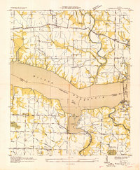 1936 Wheeler Dam1936 Print · USGSThe Tennessee River valley was undergoing a massive transformation in the mid-1930s as the TVA reservoirs filled. Local researchers can trace the early layout of Wheeler Dam Village and locate family landmarks like Fosters Mill, Center Star Sch, and Houstontown.
 - 1936 Map of Florence
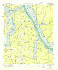
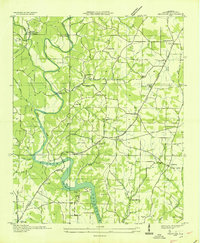
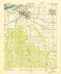
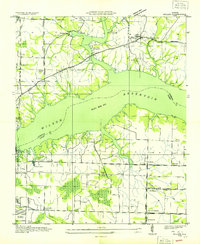
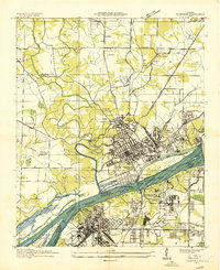 1936 Florence1936 Print · USGSThe Shoals area enters the TVA era as the river prepares for the new reservoir. Genealogists and historians can trace Oakwood Cem, the Coffee Rosenwald Sch, and early federal housing at Wilson Dam Village No 3.
 - 1936 Map of Pickwick
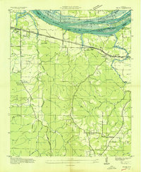
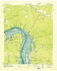 1936 Pickwick1936 Print · USGSThe Tennessee-Alabama border country stands at the brink of change during the New Deal era as the valley prepares for inundation. Genealogists can locate family landmarks like Shanghai Ch, the CCC Camp, and numerous schools including Walnut Grove Sch.
 - 1936 Map of Ransom Stand
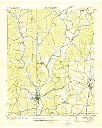
 1936 Ransom Stand1936 Print · USGSThe Tennessee-Alabama state line in the mid-1930s reveals a rural landscape defined by family-named hollows and creek-side settlements. Genealogists can trace local roots through the Centenary Cem, Stout Cem, and neighborhood schoolhouses like the Dodd Sch.
 - 1936 Map of St. Joseph
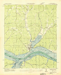
 1936 St. Joseph1936 Print · USGSThe Tennessee-Alabama borderlands come alive in the mid-1930s, showing a transition from rail-dependent industry to early highway travel. Researchers can trace the Louisville and Nashville Company line through Iron City and find rural landmarks like Wolf Creek Mill and Mt Lebo Sch.
 - 1936 Map of Center Hill
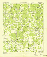
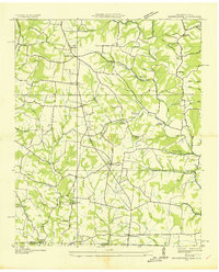
 1936 Center Hill1936 Print · USGSLauderdale County, Alabama, is documented here in the mid-1930s during the early work of the Tennessee Valley Authority. Researchers can trace family sites at Stutts Cem and Grisom Cem or locate old community centers like Arkdell and McPeters.
 - 1936 Map of Lowryville
 1936 Lowryville1936 Print · USGSThe Tennessee-Alabama borderlands come alive in this mid-1930s survey of the rural communities near Lowryville. Genealogists and historians can trace family roots through numerous local landmarks like Pollards Mill, Duncans Chapel Sch, and the uniquely named Faint Hope Cem.
 - 1936 Map of Tuscumbia
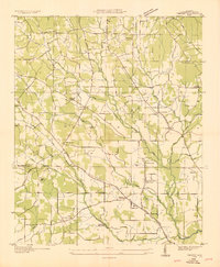
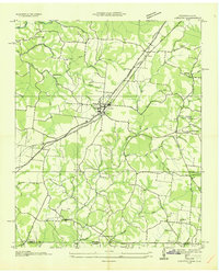
 1936 Tuscumbia1936 Print · USGSNorthwest Alabama undergoes a massive transition in the mid-thirties as federal projects reshape the Tennessee River. Trace old family roots at Underwood Cem, the early rail network through Noralia Junction, or the vanished industrial layout of Nitrate Plant No 1.
 - 1936 Map of Blackburn
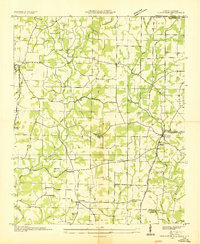
 1936 Blackburn1936 Print · USGSLauderdale County farmland was a grid of country schools and churches in the mid-thirties. Genealogists can trace family roots through landmarks like Cedar Grove Cem, Blackburn Sch, and the community of Jacksonburg.
 - 1936 Map of Cairo
 1936 Cairo1936 Print · USGSLimestone County and the newly formed Wheeler Reservoir are captured here during a pivotal era of regional change. Researchers can trace the submerged Former Tennessee River and locate community sites like Coxey and Temperance Oak Sch.
 - 1936 Map of Killen
 1936 Killen1936 Print · USGSThe Tennessee River valley transformed in the mid-thirties as hydroelectric power and industrial villages reshaped the Alabama landscape. Genealogists can locate family landmarks like Mt Pleasant Cemetery or early educational sites such as Price School and Harkins Creek School.
 - 1936 Map of Bonnertown
 1936 Bonnertown1936 Print · USGSThe Tennessee-Alabama borderlands appear here in the mid-1930s, showing a rural landscape of ridges and hollows before modernization. Genealogists can locate family-named sites like St Truitt Cem, Richardson Chapel Sch, and the community of Bonnertown.
End of results
Showing maps 1-25 of 25
Top cities of Lauderdale County
- Florence historical maps
- Underwood-Petersville historical maps
- Rogersville historical maps
- Killen historical maps
- Lexington historical maps
- Saint Florian historical maps
See more
Frequently asked questions
- What are the different types of historical maps available for Lauderdale County?
- What is the oldest map of Lauderdale County?
- Where can I purchase historical maps of Lauderdale County for my home or office?
- Where can I download high-res historical maps of Lauderdale County?
- Are there historical topographic maps available for Lauderdale County?
- Is there historical aerial imagery available for Lauderdale County?
- Where are historical maps of Lauderdale County sourced from?