1950s Maps of Lauderdale County, Alabama
Explore 33 historic maps of Lauderdale County from the 1950s. These maps offer a rare glimpse into what life looked like during the 1950s — showing old roads, neighborhoods, homes, and landmarks that have changed or disappeared over time.
Whether you're researching your family's past, planning a metal detecting trip, or studying how Lauderdale County's landscape evolved across the 1950s, these high-resolution maps are a powerful tool for exploring the history of this region.
- Focus on a specific era: All maps on this page are from the 1950s, giving you a focused view of this time period.
- See what’s changed: Compare century-old streets, trails, and buildings to today's modern landscape using overlays and satellite layers.
- Research with precision: Use these maps for genealogy, historical research, land use analysis, or educational projects.
- View, download, or print: Maps are fully viewable online in high resolution, and can be downloaded or printed for your own records.
Start exploring Lauderdale County's history through authentic maps from the 1950s. This is your window into the past.
Lauderdale County, AL maps
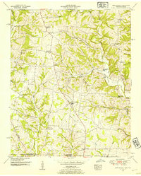
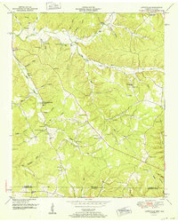
(33)- 1950 Map of Cairo
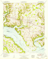
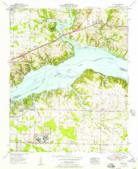
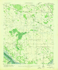
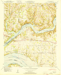 1950 Cairo1950 Print · USGSThe confluence of the Tennessee and Elk Rivers comes into focus during the late nineteen-forties as the Tennessee Valley Authority managed the developing shoreline. Genealogists can trace family names through Lentzville Cem, Confluence School, and Mt Carmel Church.4 unique versions available
 - 1950 Map of St. Joseph, 1954 Print
 1950 St. Joseph1954 Print · USGSThe Tennessee-Alabama borderlands come into focus in the early 1950s, showing the rural communities and rail lines that connected these cross-state ridges. Researchers can trace the Louisville and Nashville Railroad through Iron City or locate old burial sites like Shiloh Cem and Blair Cem.2 unique versions available
 - 1950 Map of Loretto, 1954 Print
 1950 Loretto1954 Print · USGSThe Tennessee-Alabama borderlands come alive in the early 1950s, showing the rural communities along the Louisville and Nashville corridor. Researchers can trace family roots through sites like Daisy Chapel, Rascal Town, and the McDougal Cem.3 unique versions available
 - 1950 Map of Ransom Stand, 1954 Print
 1950 Ransom Stand1954 Print · USGSThe Tennessee-Alabama borderlands at the start of the fifties reveal a landscape of deep hollows and high ridges. Genealogists can locate family names at Ransom Stand, McFalls Ch, and the Centenary Cem.2 unique versions available
 - 1950 Map of Bonnertown, 1954 Print
 1950 Bonnertown1954 Print · USGSThe Tennessee-Alabama borderland comes alive in this mid-century survey of rural Lawrence County. Researchers can trace family history through sites like Home Sweet Home Cemetery, the Bird Mill landmark, and the winding Old Rabbit Trail Road.3 unique versions available
 - 1951 Map of Union Hill
 1951 Union Hill1951 Print · USGSThe Alabama-Tennessee state line runs through this mid-century rural landscape, marked by family farms and the rising influence of the Tennessee Valley Authority. Researchers can trace the legacy of early settlements like Lester and Union Hill or locate old community hubs like Ridgway Mill and Rockaway Sch.2 unique versions available
 - 1951 Map of Whitten, 1954 Print
 1951 Whitten1954 Print · USGSThe Tennessee-Alabama borderlands come into focus in the early fifties, showing a rural landscape of ridges and creek hollows. Genealogists can trace family landmarks like Whitten Chapel, Butler Sch, and the winding path of the Chisholm Road.2 unique versions available
 - 1951 Map of Cypress Inn, 1954 Print
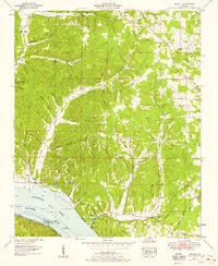
 1951 Cypress Inn1954 Print · USGSThe Tennessee-Alabama borderlands at mid-century are defined by the winding waters of Cypress Creek and the historic path of the Natchez Trace Parkway. Local historians can trace family roots through numerous landmarks like Piney Grove Ch, Cheatham School, and the Balentine Cem.3 unique versions available
 - 1952 Map of Pickwick
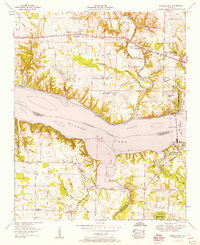
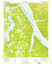
 1952 Pickwick1952 Print · USGSThe Tennessee River valley at mid-century reveals a landscape transformed by the Pickwick Landing Dam and the rising Pickwick Reservoir. Genealogists can locate rural landmarks like Shanghai Ch, Bryson Sch, and the Old White Sulphur Springs Cem.
 - 1952 Map of Lowryville
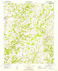
 1952 Lowryville1952 Print · USGSCovers Lauderdale County, including Lowryville, Walnut Grove, and other nearby areas
 - 1952 Map of Lexington, 1957 Print
 1952 Lexington1957 Print · USGSLauderdale County and the Tennessee borderlands are captured here in the early fifties, showing a rural landscape of scattered homesteads and family cemeteries. Genealogists can trace local roots through sites like Portertown Cem, Beaverdam Church, and the river crossing at Sledge Ford Bridge.2 unique versions available
 - 1952 Map of Wheeler Dam, 1957 Print
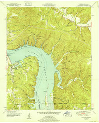
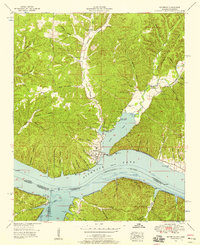
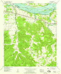
 1952 Wheeler Dam1957 Print · USGSThe Tennessee River corridor transformed in the mid-twentieth century as hydroelectric power and new state parks reshaped the Shoals region. Local historians can trace family roots through Hennigan Cem or explore the early layout of Wheeler Dam Village and Fosters Mill.
 - 1952 Map of Center Hill, 1957 Print
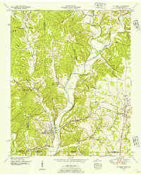
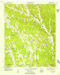
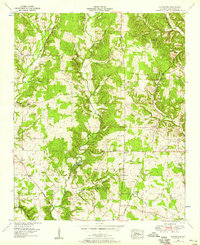
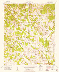
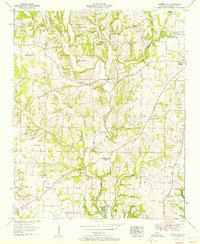 1952 Center Hill1957 Print · USGSLauderdale County is shown in the early fifties as a landscape of rural communities and winding creek valleys. Researchers can trace dozens of family landmarks and local institutions, from Sweet Gum Sch and Marys Chapel to the Minnow Hatchery at Mitchelltown.3 unique versions available
 - 1952 Map of Rogersville, 1957 Print
 1952 Rogersville1957 Print · USGSIn the early 1950s, the area around Rogersville, Alabama, was a landscape transformed by the Tennessee Valley Authority. Genealogists and historians can trace family locations through numerous rural burial grounds like McCartney Cem or visit Wheeler Dam Village and Thorntontown.2 unique versions available
 - 1952 Map of Tuscumbia, 1958 Print
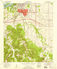 1952 Tuscumbia1958 Print · USGSTuscumbia and Sheffield are shown in detail during a period of post-war expansion along the Tennessee River. Genealogists can locate family names and rural landmarks such as Isbell Chapel, Spring Valley Church, and the Helen Keller Home alongside several country cemeteries.
 - 1952 Map of Blackburn, 1958 Print
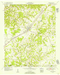
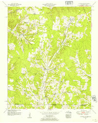
 1952 Blackburn1958 Print · USGSLauderdale County's rural heartland is captured here in the early fifties, showing a landscape of creek-side mills and historic post roads. Researchers can locate family sites near Zip City and Jacksonburg or trace the Big Cut Station Mines and Sharps Mill.3 unique versions available
 - 1952 Map of Pruitton, 1958 Print
 1952 Pruitton1958 Print · USGSLauderdale County settlement in the early fifties is captured here as the waters of Wilson Lake meet the agricultural uplands. Researchers can trace family roots through numerous landmarks like Bailey Springs, Milners Chapel, and the Pleasant Grove Cem.3 unique versions available
 - 1953 Map of Killen, 1957 Print
 1953 Killen1957 Print · USGSThe Tennessee River valley in the early fifties shows a landscape reshaped by industry and the waters of Wilson Lake. Researchers can trace the development of Nitrate City and Listerhill or find family landmarks like Old Brick Ch and Woodlawn Cem.
 - 1953 Map of Wright, 1958 Print
 1953 Wright1958 Print · USGSLauderdale County's southern border met the waters of the Tennessee River in the early fifties, following the creation of Pickwick Lake. Genealogists can trace family landmarks through the numerous hollows and country churches like Oak Grove Ch and Murphy Chapel.3 unique versions available
 - 1953 Map of Yellow Creek, 1958 Print
 1953 Yellow Creek1958 Print · USGSTishomingo County sits at a three-state crossroads during the early fifties as the river valley adjusts to the presence of Pickwick Lake. Researchers can trace old family landmarks like Hubbard Cem and Short Creek Cem or the river landing at Cooks Landing.6 unique versions available
 - 1953 Map of Waterloo, 1958 Print
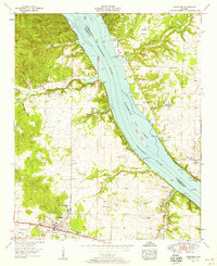
 1953 Waterloo1958 Print · USGSThe Alabama and Mississippi borderlands meet at the Tennessee River in the mid-fifties, just as the regional economy shifted toward the new reservoir. Researchers can locate family landmarks like Richardson Cem, Barrett Mill, and the small riverfront town of Waterloo.3 unique versions available
 - 1954 Map of Sinking Creek
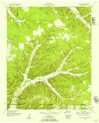
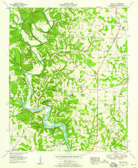
 1954 Sinking Creek1954 Print · USGSLauderdale County is captured here in the mid-1930s as the Tennessee Valley Authority began transforming the landscape. Researchers can trace ancestral locations like Oakland, the Lipscomb Cem, and the Lovelace Sch before the reservoir waters rose.4 unique versions available
 - 1954 Map of Threet, 1958 Print
 1954 Threet1958 Print · USGSLauderdale County in the mid-fifties is seen here through its rural network of community churches and the historic Natchez Trace Parkway. Local historians can trace old property boundaries near Sullivan Crossroads, Threet, and the Little Zion Church.4 unique versions available
 - 1954 Map of Pride, 1958 Print
 1954 Pride1958 Print · USGSColbert County and the Tennessee River corridor are captured here during the mid-fifties industrial expansion. You can trace the rail-and-river economy near Pride and find rural landmarks like Zion Ch, Barton Sch, and the riverside Colbert Steam Plant.
 - 1954 Map of Cherokee, 1958 Print
 1954 Cherokee1958 Print · USGSCherokee and the Tennessee River valley are documented here in the mid-fifties as the region balanced its rail-town roots with new shoreline developments. Local historians can trace old wagon routes and family landmarks like Monk Chapel, Smithsonia, and the historic Natchez Trace.4 unique versions available
Showing maps 1-25 of 33
Top cities of Lauderdale County
- Florence historical maps
- Underwood-Petersville historical maps
- Rogersville historical maps
- Killen historical maps
- Lexington historical maps
- Saint Florian historical maps
See more
Frequently asked questions
- What are the different types of historical maps available for Lauderdale County?
- What is the oldest map of Lauderdale County?
- Where can I purchase historical maps of Lauderdale County for my home or office?
- Where can I download high-res historical maps of Lauderdale County?
- Are there historical topographic maps available for Lauderdale County?
- Is there historical aerial imagery available for Lauderdale County?
- Where are historical maps of Lauderdale County sourced from?