1980s Maps of Fort Deposit, Alabama
Explore 3 historic maps of Fort Deposit from the 1980s. These maps offer a rare glimpse into what life looked like during the 1980s — showing old roads, neighborhoods, homes, and landmarks that have changed or disappeared over time.
Whether you're researching your family's past, planning a metal detecting trip, or studying how Fort Deposit's landscape evolved across the 1980s, these high-resolution maps are a powerful tool for exploring the history of this region.
- Focus on a specific era: All maps on this page are from the 1980s, giving you a focused view of this time period.
- See what’s changed: Compare century-old streets, trails, and buildings to today's modern landscape using overlays and satellite layers.
- Research with precision: Use these maps for genealogy, historical research, land use analysis, or educational projects.
- View, download, or print: Maps are fully viewable online in high resolution, and can be downloaded or printed for your own records.
Start exploring Fort Deposit's history through authentic maps from the 1980s. This is your window into the past.
Fort Deposit, AL maps
(3)- 1981 Map of Calhoun
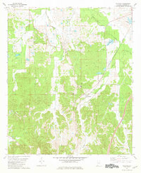 1981 Calhoun1981 Print · USGSLowndes County's rural character and rail connections are visible here in the early 1980s, focused on the settlement of Calhoun. Researchers can trace the Louisville and Nashville rail line and locate community hubs like Big Union Ch and New Hope.
 - 1986 Map of Montgomery
 1986 Montgomery1986 Print · USGSCentral Alabama's river-and-rail corridor is captured in the mid-1980s, centered on the state capital and its surrounding rural counties. Researchers can trace ancestral landmarks like Oakwood Cemetery, military sites like Maxwell Air Force Base, and small towns such as Lowndesboro.2 unique versions available
 - 1986 Map of Greenville
 1986 Greenville1986 Print · USGSMid-century South Central Alabama comes alive in this survey of the creek-laced timberlands and rail-dependent towns between the Gulf Coastal Plain and the Piedmont. Researchers can trace family roots through numerous country landmarks like Magnolia Cem, Spring Hill Ch, and the Butler County State Wildlife Management Area.2 unique versions available
End of results
Showing maps 1-3 of 3
Top cities near Fort Deposit
- Greenville historical maps
- Mosses historical maps
- Hayneville historical maps
- Gordonville historical maps
Frequently asked questions
- What are the different types of historical maps available for Fort Deposit?
- What is the oldest map of Fort Deposit?
- Where can I purchase historical maps of Fort Deposit for my home or office?
- Where can I download high-res historical maps of Fort Deposit?
- Are there historical topographic maps available for Fort Deposit?
- Is there historical aerial imagery available for Fort Deposit?
- Where are historical maps of Fort Deposit sourced from?