1900s (20th Century) Maps of White Hall, Alabama
Explore 10 historic maps of White Hall from the 1900s (20th Century). These maps offer a rare glimpse into what life looked like during the 1900s — showing old roads, neighborhoods, homes, and landmarks that have changed or disappeared over time.
Whether you're researching your family's past, planning a metal detecting trip, or studying how White Hall's landscape evolved across the 1900s, these high-resolution maps are a powerful tool for exploring the history of this region.
- Focus on a specific era: All maps on this page are from the 1900s, giving you a focused view of this time period.
- See what’s changed: Compare century-old streets, trails, and buildings to today's modern landscape using overlays and satellite layers.
- Research with precision: Use these maps for genealogy, historical research, land use analysis, or educational projects.
- View, download, or print: Maps are fully viewable online in high resolution, and can be downloaded or printed for your own records.
Start exploring White Hall's history through authentic maps from the 1900s. This is your window into the past.
White Hall, AL maps
(10)- 1953 Map of Montgomery, 1964 Print
 1953 Montgomery1964 Print · USGSCentral Alabama's river-and-rail corridor is mapped here in the mid-fifties, showing the vital connections between the capital and the Black Belt. Genealogists and historians can trace rail depots and crossroads from Marion Junction to Wetumpka, alongside landmarks like Craig AFB.4 unique versions available
 - 1956 Map of Montgomery
 1956 Montgomery1956 Print · USGSCentral Alabama in the mid-1950s shows a landscape defined by its great river systems and a booming military aviation presence. Genealogists and historians can trace the rail corridors of the Southern Railway and locate tactical bases like Maxwell AFB and Craig AFB.
 - 1957 Map of Montgomery
 1957 Montgomery1957 Print · USGSCentral Alabama in the mid-fifties is defined by the winding Alabama River and a strategic network of military bases and rail lines. Trace family roots in Montgomery and Selma, or locate landmarks like Craig AFB and the State Capitol before the interstate era.
 - 1957 Map of Autaugaville, 1958 Print
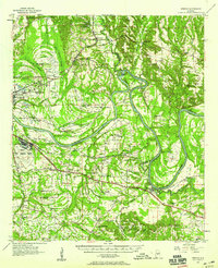
 1957 Autaugaville1958 Print · USGSThe Alabama River and the Western Railway of Alabama define the landscape of Autauga and Lowndes Counties in the late fifties. Genealogists can trace family landmarks like Yankee Town Cem, Morning Star Sch, and the rail stop at St Clair.2 unique versions available
 - 1957 Map of Benton, 1958 Print
 1957 Benton1958 Print · USGSThe river country along the Alabama-Lowndes border in the late fifties is defined by the deep oxbows of the Alabama River. Genealogists and researchers can trace rural life through a network of landmarks like Pine Flat Ch, the Dulaney Sch, and the rail stops at Benton and Tyler.2 unique versions available
 - 1975 Map of Benton SE
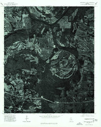
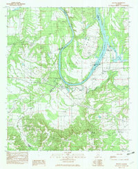
 1975 Benton SE1975 Print · USGSBenton and the surrounding Lowndes County bottomlands are captured in detail during the mid-1970s. This aerial orthophotoquad allows researchers to see the actual fields and structures around the Benton settlement and the wide curves of the Alabama River.
 - 1975 Map of Autaugaville SW, 1977 Print
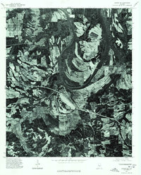
 1975 Autaugaville SW1977 Print · USGSLowndes County lands south of the Alabama River are shown in high-contrast aerial detail during the mid-seventies. Genealogists and land researchers can trace property lines and field patterns surrounding the settlement of White Hall.
 - 1982 Map of White Hall
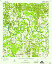
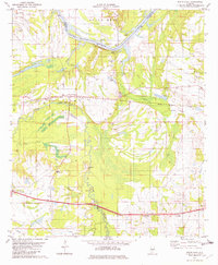 1982 White Hall1982 Print · USGSWhite Hall and the Alabama River are captured in the early 1980s, showcasing a landscape of fertile bends and rail-side settlements. Genealogists can trace family roots through several local landmarks like Hall Cem, Trickem, and Wright Chapel.
 - 1982 Map of Benton, 1983 Print
 1982 Benton1983 Print · USGSThe Alabama River and its complex system of locks and dams define this Lowndes County landscape during the early 1980s. Researchers can trace rural community centers such as Petronia, Benton, and Trickem alongside major landmarks like the Robert F Henry Lock and Dam.
 - 1986 Map of Montgomery
 1986 Montgomery1986 Print · USGSCentral Alabama's river-and-rail corridor is captured in the mid-1980s, centered on the state capital and its surrounding rural counties. Researchers can trace ancestral landmarks like Oakwood Cemetery, military sites like Maxwell Air Force Base, and small towns such as Lowndesboro.2 unique versions available
End of results
Showing maps 1-10 of 10
Top cities near White Hall
- Prattville historical maps
- Mosses historical maps
- Hayneville historical maps
- Autaugaville historical maps
- Gordonville historical maps
- Lowndesboro historical maps
See more
Top neighborhoods of White Hall
Frequently asked questions
- What are the different types of historical maps available for White Hall?
- What is the oldest map of White Hall?
- Where can I purchase historical maps of White Hall for my home or office?
- Where can I download high-res historical maps of White Hall?
- Are there historical topographic maps available for White Hall?
- Is there historical aerial imagery available for White Hall?
- Where are historical maps of White Hall sourced from?